Multimodal Systems
The West Plains communities, with significant low-income populations, is reliant on public transportation and non-motorized travel. However, the area currently offers limited multi-use paths, carpooling, or alternative modes such as rental bicycles, etc.
Bicycle and Pedestrian Networks
Bicycle facilities are limited in the study area, with portions of a shared use path in place along the north side of US 2 between Garfield Road and Deer Heights Road and traditional bike lanes striped on Hayford Road between US 2 and Northern Quest Drive. Shoulders are available along US 2; however, traffic volumes and speeds make the use of these uncomfortable for most bicyclists. The shared use paths along US 2 also provide pedestrian connectivity. Other sections of the study corridor provide a combination of attached and detached sidewalks; however, gaps remain.
The interactive map tool below contains information about existing and planned bicycle and pedestrian networks in the study area that can be turned on/off.
Safe Routes to School (SRTC)
The Safe Routes to School Program is a federally funded reimbursement program that promotes walking and bicycling to school through improving infrastructure (such as addressing the missing gaps in sidewalks, lack of identified crossings, etc.), enforcement, safety, and education. Currently, there is one elementary school within the study area: Sunset Elementary located at 12824 W 12th Ave in Airway Heights. The image below illustrates the Safe Routes to School map for the school, which was provided by T-O Engineers.
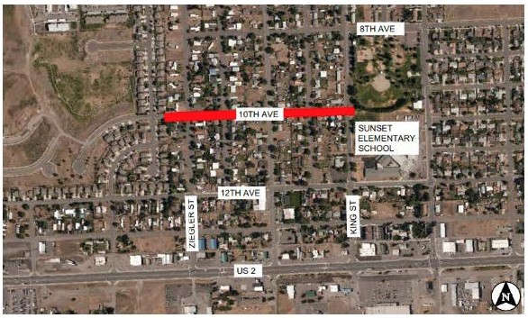
Source: T-O Engineers
Public Transit
The Spokane Transit Authority (STA) is the regional public transit provider that serves the study area. STA provides a total of seven fixed-routes that serve/traverse the study area, as well as paratransit demand-response service. Some of these routes access the new West Plains Transit Center, which is located to the east of the I-90 / SR 902 interchange. The following table summarizes the seven fixed-route bus services within the study area. The most current operating times, routing, and other route information can be found by clicking a route in the table. Information about STA’s entire network of transit routes can be found on STA’s Routes & Schedules page.
STA Study Area Fixed-Route Bus Routes
| Route Number | Type | Description |
|---|---|---|
| 6 & 66 | Basic | Provides service between downtown Spokane and the City of Cheney, with a stop at the West Plains Transit Center. |
| 60 | Basic & Limited | Provides service to the Spokane International Airport via Browne’s Edition. This route begins/ends at the STA Plaza in downtown Spokane and provides service to Airway Heights traveling to the Spokane International Airport, Northern Quest Casino, Airway Heights Correctional Facility, and the Spokane Tribe Casino. |
| 61 | Basic | Provides service along US 2 to Fairchild Air Force Base via Browne’s Edition. This route begins/ends at the STA Plaza in downtown Spokane and provides service to Airway Heights along US 2 to Hayford Road, then north to Northern Quest Casino and the Airway Heights Correctional Facility, then returning to US 2 to serve the Spokane Tribal Casino and into Fairchild Air Force Base. |
| 62 | Basic | Provides service to the City of Medical Lake from downtown Spokane, with a stop at the West Plains Transit Center. |
| 63 | Basic | Provides service form the new West Plains Transit Center to downtown Airway Heights. This route begins/ends at the West Plains Transit Center and provides service west along Geiger Blvd., north along Spotted Road, a loop that access the Spokane International Airport, north along Flint Road to US 2, west along US 2 to Hayford Road intersecting with Routes 60/61, and then to Lundstrom Street. |
| 633 | Basic | Provides service between the West Plains Transit Center and the new Amazon distribution center. |
The interactive map tool below contains STA’s routes and stops, which can be turned on/off.
STA also has plans for a high performance transit (HPT) line that is planned for implementation by 2040, but no detailed planning or design has been conducted for this line and it is not currently funded.
Multimodal Needs
A multimodal focus was used throughout the study efforts and found that improvements to all modes – bicyclists, pedestrians, vehicles, freight, and transit – will be required to address existing and future mobility and safety needs. Multimodal strategies are provided on the Final Outcomes / Practical Solutions page.