Welcome to the Online Open House for the West Plains Subarea Transportation Management Plan Phase 1, US 2 Vicinity study report. The Open House was held August 23-September 3, 2021. The following content was retained to document the event.
The Open House is divided into six “stations” for you to visit. You are welcome to visit the “stations” in order by scrolling down the page, or jump to a particular “station” of interest:
- Project Summary
- Considerations Driving the Study
- Project History and Study Progress
- Strategies
- Feedback
- Thank you!
Project Summary
Overview
The West Plains Subarea Transportation Management Plan Phase 1, US 2 Vicinity study is an analysis of land use growth and transportation issues through the year 2040. The purpose of the study is to develop practical multimodal solutions to address identified issues for the US 2 corridor from Mitchell Rd to Airport Dr.
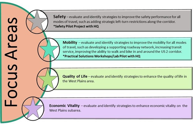
The study has four focus areas that have driven the development of strategies along the corridor.
- Safety
- Mobility
- Quality of Life
- Economic Vitality
Strategies
To address the identified land use and transportation concerns, strategies that are in alignment with the focus areas were developed by WSDOT and study area partners under the following categories:
- Safety
- Freight
- Environmental
- Equity
- Active & Public transportation
- Transportation Management Systems Operations (TSMO)
- Traffic Operations
- Land Use
To specifically address traffic circulation issues, a Traffic Circulation Plan was developed to define intersection and access improvements along the corridor in conjunction with planned new parallel routes of 6th/10th/12th Ave to the north and 18th/21st Ave to the south to be implemented by other area partners.
Tables listing the multimodal and traffic circulation strategies, including detailed tables and maps in PDFs, are available in the strategies section of the open house.
Considerations Driving the Study
Focus Areas
Four Focus Areas have driven the analysis and development of strategies for the study:
Land Use Growth
The West Plains, specifically along the US 2 corridor, is one of the fastest growing land use development areas in Washington State. The current and projected growth was a major driver for the transportation needs considered by this study.
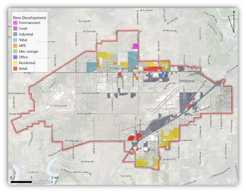
Current Development Projects
The following are some of the current development project occurring along and around the corridor:
- Abott Industrial park
- Aspen Single Family Home Development ~500 units
- Kalispel Tribe Expansion Developments
- North 40 Outfitters
- Spokane Airport Transload Facility
- Spokane Tribe Development
- Hunters Crossing
- Puget Pipe and McKinstry Co.
Market Land Use Assessment
The Leland Consulting Group was contracted to conduct a Market Land Use assessment, which was an economic analysis of demographics, employment, development trends, and forecasted demand along with stakeholder interviews to better estimate the development potential of vacant and underutilized properties within the study area. This information was used to better refine the traffic forecasts for the planning horizon year of 2040.
The assessment found there are ample opportunities for continued land use growth in the study area and concluded the following development trends:
- Continued tribal land build out, with major development expected
- Additional Amazon and associated development
- US 2 and I-90 build out, with development clustering around these facilities
- Potential but highly unpredictable development on airport-owned land
- Hotel growth
- Limited office (innovation park)
- Unprecedented rate of development, especially housing (both single- and multi-family, and growth in industrial uses and Fairchild Airforce Base (FAFB)
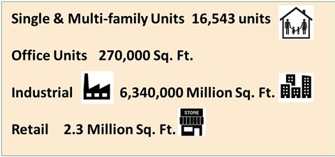
The assessment estimated the following demand in new development through 2040:
Multimodal System Needs
The study found that improvements to all modes will be required to address existing and future Mobility and Safety needs. Multimodal strategies are provided in the strategies section.
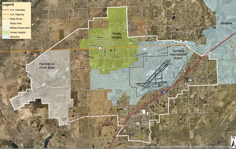
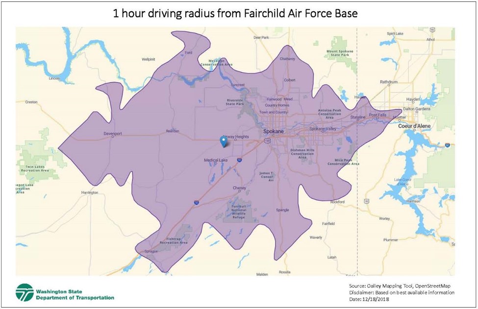
Fairchild Air Force Base
Fairchild AFB requires all service members to reside within an hour travel time of the base. The following map illustrates this area today. As travel time increases, the allowable area to reside decreases, giving service members less choice in where they can live.
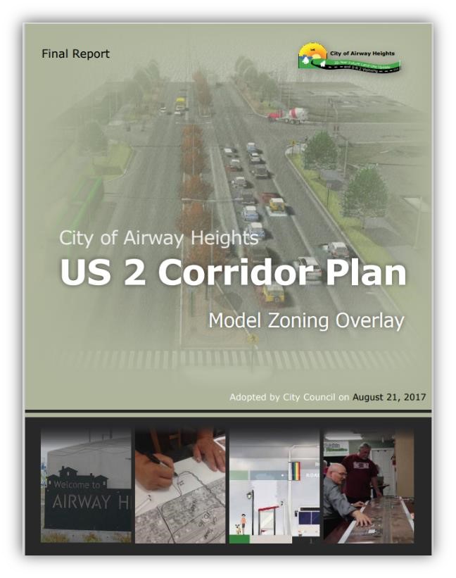
City of Airway Heights Downtown Revitalization Plan
In 2017, the City of Airway Heights completed the US 2 Corridor Plan: Model Zoning Overlay, known as the Downtown Revitalization Plan. The plan defines the desired typical cross-section for six “context areas”.
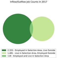
Commute Patterns
An analysis of Census data revealed that very few people who live in Airway Heights work within the City, meaning there is a heavy commute pattern for both residents of the study area leaving the area to work and people living outside the study area coming in to work.
Project History and Study Progress
The study corridor has been analyzed by several different entities over the years.
As part of this study, the following accomplishments have been achieved to produce the strategies for the study report, as shown in the Strategies section.
- Purpose & Need of the project
- Methods and assumptions document for conducting the study
- Environmental Justice Assessment
- Origin & Destination Analysis (where trips originate from and go to)
- Environmental Assessment
- Extensive community engagement, including a two-part survey developed by the City of Airway Heights and WSDOT hat received over 600 responses
- Traffic Circulation Plan
Additionally, several firsts and innovations for WSDOT Eastern Region were achieved as part of this study:
- Creation of a “living study” website
- Safety assessment of the corridor
- Planning level traffic analysis of operations along the corridor
- Practical Solutions Lab, which involved stakeholders developing the strategies shown in this open house
- Multimodal Practical Solutions strategies list
Strategies
Multimodal
As noted in the Summary section, a multitude of strategies were developed for all modes and across several categories beyond just transportation.
Categorized List of Multimodal Practical Solutions Strategies Prioritized by Percentage of Effectiveness (PDF 184 KB)
Traffic Circulation Plan
Specific to the roadway, the following are strategies to improve traffic circulation in conjunction with the planned 6th/10th/12th Ave and 18th/21st Ave parallel roadway networks.
Final Traffic Circulation Plan Strategy from West Plains Subarea Study (PDF 139 KB)
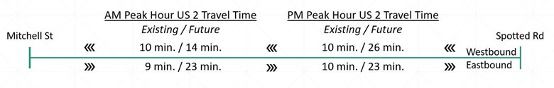
Despite these improvements, travel times along the corridor – in both directions, and both the morning and evening peak hours – are expected to increase, as shown below. This increases the importance of the multimodal strategies presented above to provide additional and improved travel choices.
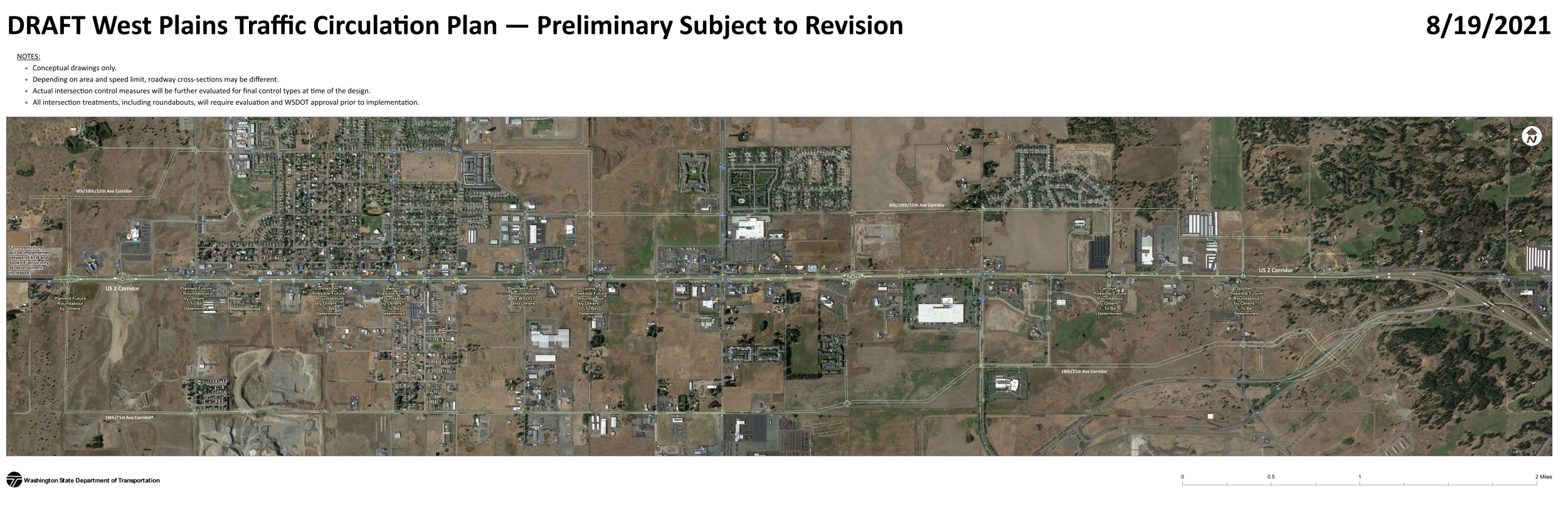
Traffic Circulation Plan map (PDF 6 MB)
Current Infrastructure Projects
In addition to the study’s strategies, the following are other current infrastructure projects that are planned:
- Hayford Road Dual Southbound Left Lanes Project
- 6th/10th/12th Parallel Roadway Network – Partial Build Grant
- Spoko Fuel Roundabout
- Craig Rd Roundabout
- Lyons Rd Improvements
- Spokane Transit Authority – High Performance Transit Lines
Feedback
For any feedback, questions or concerns, please visit our Contact / About us page.
Thank you!
The WSDOT project team and study area partners would like to thank you for attending the Online Open House! More information about the study and the various steps of the project can be found within the rest of the ConnectWestPlains.com website.