The West Plains area was found to be one of the fastest growing areas in Washington State as defined in a final Research Report “Land Development Risks Along State Transportation Corridors” led by the University of Washington in a collaborative joint effort with WSDOT and the Spokane Regional Transportation Council (SRTC). The West Plains Subarea Transportation Management Plan Phase 1, US 2 Vicinity study recognizes the need to study and identify what is the best multimodal transportation network to keep up with the growing land use demand, particularly in and around US 2, and to collaboratively refine past study efforts and plan for potential “practical solutions” that can be jointly prioritized and programmed.
Previous West Plains Studies and Plans
Over 18 studies by various jurisdictions and agencies have been completed in the West Plains area since 2006. The following is a comprehensive list of the past studies and plans evaluated, refined, and incorporated into this study effort:
- 2006 – City of Airway Heights – Highway 2 Revitalization
- 2009 – City of Spokane – Master Bike Plan
- 2009 – Fairchild Air Force Base (FAFB) – Joint Land Use Study (JLUS)
- 2010 – WSDOT – Washington Airport & Compatible Land Use Guidebook
- 2010 – WSDOT – US 2 Route Development Plan, Lincoln Co. Line to I-90 MP 266.86 to MP 283.01
- 2011 – SRTC – West Plains-Spokane International Airport (SIA) Transportation Study
- 2011 – Spokane Tribe – West Plains Development TIA
- 2012 – Spokane County – Comprehensive Plan
- 2012 – City of Spokane – Spokane AIR – West Site Transportation Analysis
- 2013 – WSDOT – Land Development Risks along State Transportation Corridor
- 2013 – Value Management Strategies – VE Study I-90/SR 902 I/C Improvements
- 2014 – City of Spokane – West Plains Subarea Transportation Plan
- 2014 – Spokane International Airport – Master Plan
- 2015 – Morrison Maierle, Inc. – Rowand Business Park
- 2016 – City of Spokane – Comprehensive Plan update 2017
- 2016 – City of Spokane – Comprehensive Plan 2017 Appendix D update
- 2017 – City of Airway Heights- Transportation Circulation Plan
- 2017 – City of Airway Heights – US 2 Plan Model Zoning Overlay
- 2018 – WSDOT – Corridor Sketch Initiative, US 2: Craig Rd to Russell Rd, MP 277.2 to MP 281.5
- 2018 – Project Rose Traffic Impact Analysis
- 2018 – WSDOT – Four Lakes to Idaho Operations Study
- 2019 – WSDOT – Spokane Region ITS Architecture Plan
- 2020 – City of Airway Heights – US 2 Corridor Plan (Downtown Revitalization Plan)
- 2021 – S3R3 – West Plains Connection, 16th/10th/12th Corridor Design Report (ongoing)
Study Process
A Technical Advisory Team (TAT) was developed for the study, comprised of professional staff from WSDOT and our study partner agencies (see the Contact / About Us page for more info on the study partners and TAT members). With regular meetings, the TAT provided technical assistance and made key decisions such as determining the methodology for this study. Every step of the study process was vetted though the TAT. The following provide foundational elements developed by the TAT to shape and guide the study.
Identifying “Success”
The TAT was asked at the beginning of the study: “What would success look like for partnering jurisdictions transportation needs in and around the West Plains?” During initial collaboration with the study partners, 21 “Guidelines for Success” were developed, with the following seven identified as areas of highest importance as selected by the TAT:
- Buy-in from local jurisdictions to support the outcome, being mindful of limited funding opportunities.
- Maintaining Fairchild response time.
- Quality of life improvements and Pedestrian and Multimodal Safety.
- Plan ahead of land use changes.
- Maintain reliability for trucking, freight and commercial uses along the corridor.
- Reliable alternate routes to serve regional and local travel.
- Support the downtown plan of Airway Heights.
Objectives
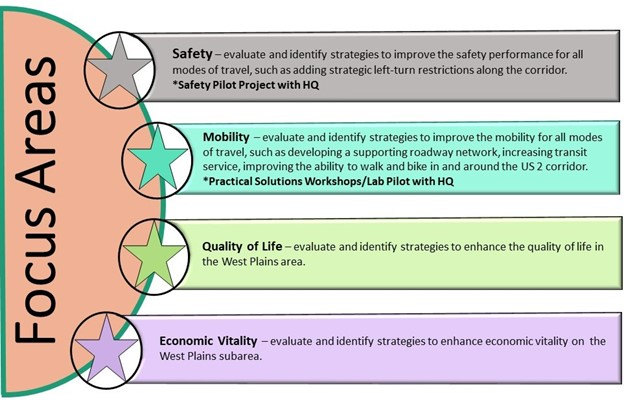
The TAT developed the following objectives as focus areas for the study:
- Safety – evaluate and identify strategies to improve the safety performance for all modes of travel, such as adding strategic left-turn restrictions along the US 2 corridor.
(*Safety Pilot Project with WSDOT HQ) - Mobility – evaluate and identify strategies to improve the mobility for all modes of travel, such as developing a supporting local roadway network, increasing transit service, improving the ability to walk and bike in and around the US 2 corridor.
(*Practical Solutions Workshops/Lab Pilot with WSDOT HQ) - Quality of Life – evaluate and identify strategies to enhance the quality of life in the West Plains area.
- Economic Vitality – evaluate and identify strategies to enhance economic vitality in the West Plains subarea.
Guiding Principles
Guiding principles developed for the study include:
- The study will review previously proposed identified and emerging solutions and explore “Practical Solutions” to mitigate the identified issues.
- Local agency partners, the Spokane Tribe, the Kalispel Tribe, Spokane Transit Authority, Spokane International Airport, Fairchild Air Force Base, and the Spokane Regional Transportation Council will collaborate in all phases of the study. The partners will collaboratively review past studies, past Intersection for Approvals, the County Urban Growth Area (UGA), zoning codes, comprehensive plans, corridor sketch, and other documents pertaining to the West Plains.
- Community engagement will be inclusive and transparent. We will involve a wide array of perspectives, disciplines, and backgrounds in our outreach and decision making.
- Quantitative analysis will be used to confirm issues and advance potential solutions.
Targeted Outcomes
The guiding principles led to the following targeted outcomes for the study:
- Create a plan to address transportation needs that are based on land use growth projections, and includes a prioritized list of strategies and funding options.
- Identify local network improvements that will support US 2 mobility, including parallel corridor such as 6th /10th/12th Ave and the 18th/21st Ave. Determine the local alignments and connections to the transportation system.
- Identify achievable “practical solutions” system improvements, including on and off the state network prioritization, future programming and implementation.
- Select strategies that promote predictable and reliable travel and response times for emergency services and Fairchild Air Force Base.
- Identify potential right of way needs.
- Analyze the impacts of land use development in the West Plains to US 2 and the regional network.
- Review previous West Plains study outcomes to identify opportunities to further advance and/or adjust as needed to align with current goals and performance needs.