¿En qué consiste el proceso NEPA?
El proceso de la Ley Nacional de Política Medioambiental (NEPA) evalúa cómo un determinado proyecto impacta sobre el medio ambiente. El WSDOT analizará una serie de aspectos para determinar el impacto que tendrá el proyecto en los recursos naturales, culturales y construidos de la zona.
Actualmente nos encontramos en la fase de definición de alcance del proceso. El WSDOT determinará lo que se estudiará en la EA. En esta etapa se dará la oportunidad a colaboradores del proyecto y al público de que aporten su opinión. Estas aportaciones ayudarán a determinar qué debe incluirse en la EA.
Una vez que el WSDOT haya completado la EA, se podrán aportar comentarios sobre los resultados. Esta información contribuirá al diseño final del proyecto y a la planificación de la construcción.
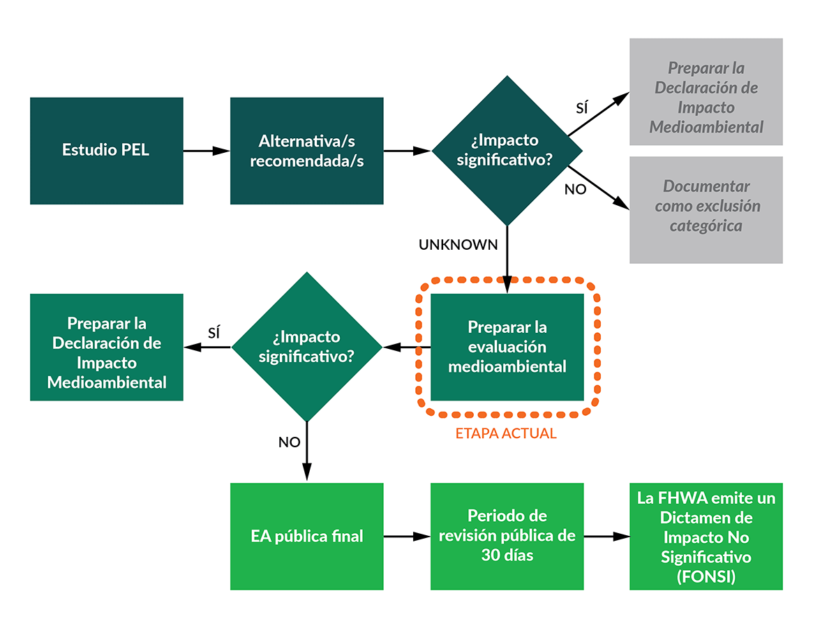
Lo que el WSDOT estudiará durante la Evaluación Ambiental
Durante la EA, el WSDOT evaluará los posibles beneficios, impactos y estrategias de mitigación de estos importantes elementos del proyecto:
- Ampliar la I-5 añadiendo un carril para vehículos de alta ocupación en cada dirección desde aproximadamente Marvin Road, en el condado de Thurston, hasta Mounts Road, en el condado de Pierce.
- Reemplazar los puentes existentes y construir nuevos puentes en el delta del río Nisqually para aumentar la resiliencia de la I-5 a las inundaciones y a la subida del nivel del mar y mejorar el hábitat.
- Construir un nuevo paso a nivel del ferrocarril BNSF al este del río Nisqually.
- Reconducir el arroyo McAllister donde cruza la I-5 para mejorar el efecto del cambio de mareas, la calidad del agua y el hábitat de los peces.
- Construir un camino de uso compartido adyacente a la I-5, que proporcione una conexión no motorizada entre Lacey y DuPont, y mejorar el acceso a la zona de Billy Frank Jr. Reserva Nacional de Vida Silvestre de Nisqually.
- Eliminar dos barreras existentes para el paso de peces bajo la autopista I-5 en el drenaje del arroyo Red Salmon.
- Instalar nuevas zonas para el tratamiento de aguas pluviales para tratar la escorrentía de la I-5 dentro del proyecto.
- Mejorar el hábitat circundante y permitir la creación de un nuevo hábitat donde se eliminaría el terraplén existente de la I-5.
La siguiente lista incluye categorías medioambientales que podrían verse impactadas o beneficiadas por el proyecto. El WSDOT identificó estas categorías durante el PEL mientras se estudiaban las condiciones existentes. Estas categorías medioambientales se estudiarán en detalle durante la EA.
- Aguas pluviales y calidad del agua
- Humedales y otras aguas
- Peces, fauna y vegetación
- Llanuras aluviales y subida del nivel del mar
- Geología y suelos
- Calidad visual
- Calidad del aire, gases de efecto invernadero y energía
- Recursos culturales
- Ruido
- Materiales peligrosos
- Uso del suelo, tierras agrícolas y Sección 6(f) – Fondo para la Conservación del Suelo y el Agua en zonas recreativas al aire libre
- Sección 4(f) – Parques, zonas recreativas, refugios y lugares históricos
- Justicia socioeconómica y medioambiental
Para más información sobre cada uno de estos temas, consulte el Reporte Final del Estudio PEL (PDF 4.8MB).
Alternativa de no construir
La NEPA también requiere una evaluación de una alternativa de No Construir. La alternativa de No Construir mantendría la autopista en su configuración actual. La EA estudiará cuáles serían los efectos si no se construyera el proyecto, incluyendo el estudio del riesgo de no actualizar las estructuras envejecidas. La alternativa de No Construir sirve como línea de base para comparar con la alternativa de Construir.
Reducir las opciones de longitud de los puentes
El Estudio PEL identificó tres posibles opciones de longitud del puente de la zona del proyecto. Desde que finalizó el Estudio PEL, el WSDOT redujo estas opciones haciendo análisis adicionales:
- La opción de longitud del puente de 6,000 pies reemplazaría los puentes del río Nisqually. Esta opción eliminaría parte de la tierra y suciedad que sostiene la I-5 a través del delta. También añadiría aproximadamente 6,000 pies de nueva estructura de puente en el lado este del delta.
- Esta opción reconduciría el arroyo McAllister para proporcionar un cauce más natural.
- La opción de longitud del puente de 12,000 pies reemplazaría los puentes del río Nisqually. Esta opción eliminaría toda la tierra y suciedad que sostiene la I-5 a través del delta. También añadiría aproximadamente 12,000 pies de nueva estructura de puente que abarcaría toda la anchura del delta.
- Esta opción reconduciría el arroyo McAllister e incluiría un nuevo enlace elevado de la I-5 en la salida 114.
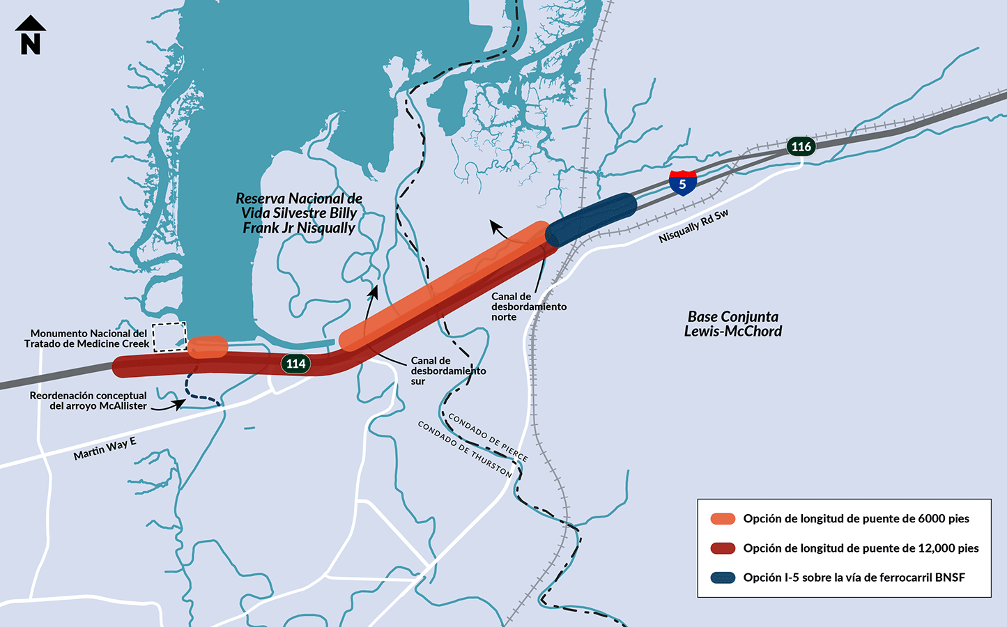
medioambiental (EA) de la NEPA.
El WSDOT no está considerando la opción de longitud del puente de 3,000 pies en el análisis de la NEPA. La opción del puente de 3,000 pies no abarcaría los cauces históricos del río Nisqually. Esto significa que no se restauraría el flujo natural de agua en el delta como con las opciones de 6,000 y 12,000 pies. También sería potencialmente vulnerable a la futura erosión del cauce.
Construcción de un nuevo cruce de las vías del ferrocarril BNSF
Actualmente, la I-5 cruza por debajo de la vía principal del ferrocarril BNSF que une Tacoma y Portland. Esta vía ferroviaria presta servicio a unos 40 trenes de mercancías al día. Los puentes BNSF existentes sobre la I-5 no son lo suficientemente largos para poder añadir los carriles de alta ocupación (HOV) de la I-5 y el camino de uso compartido propuestos. El WSDOT está estudiando dos opciones para el cruce de la I-5 con la vía ferroviaria BNSF.
Opción 1: I-5 sobre BNSF – Concepto propuesto
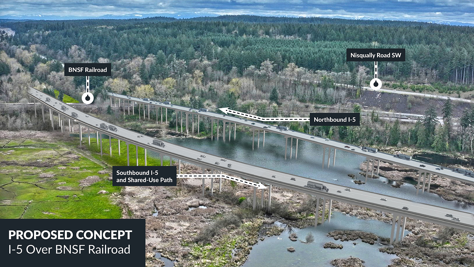
En esta propuesta se construiría un puente de la I-5 sobre la vía ferroviaria BNSF en ambas direcciones. La estructura de la autopista tendría unos 1,700 pies de longitud. El punto más alto estaría a casi 60 pies por encima de la superficie existente. Eso proporcionaría un espacio de 23.5 pies por encima de las vías de BNSF. Después de cruzar las vías, la estructura descendería en pendiente hacia el oeste para conectar con el nuevo puente. La pendiente permitiría que la escorrentía de las aguas pluviales fluyera hacia las zonas de tratamiento sin afectar a hábitats sensibles.
Opción 2: I-5 bajo BNSF
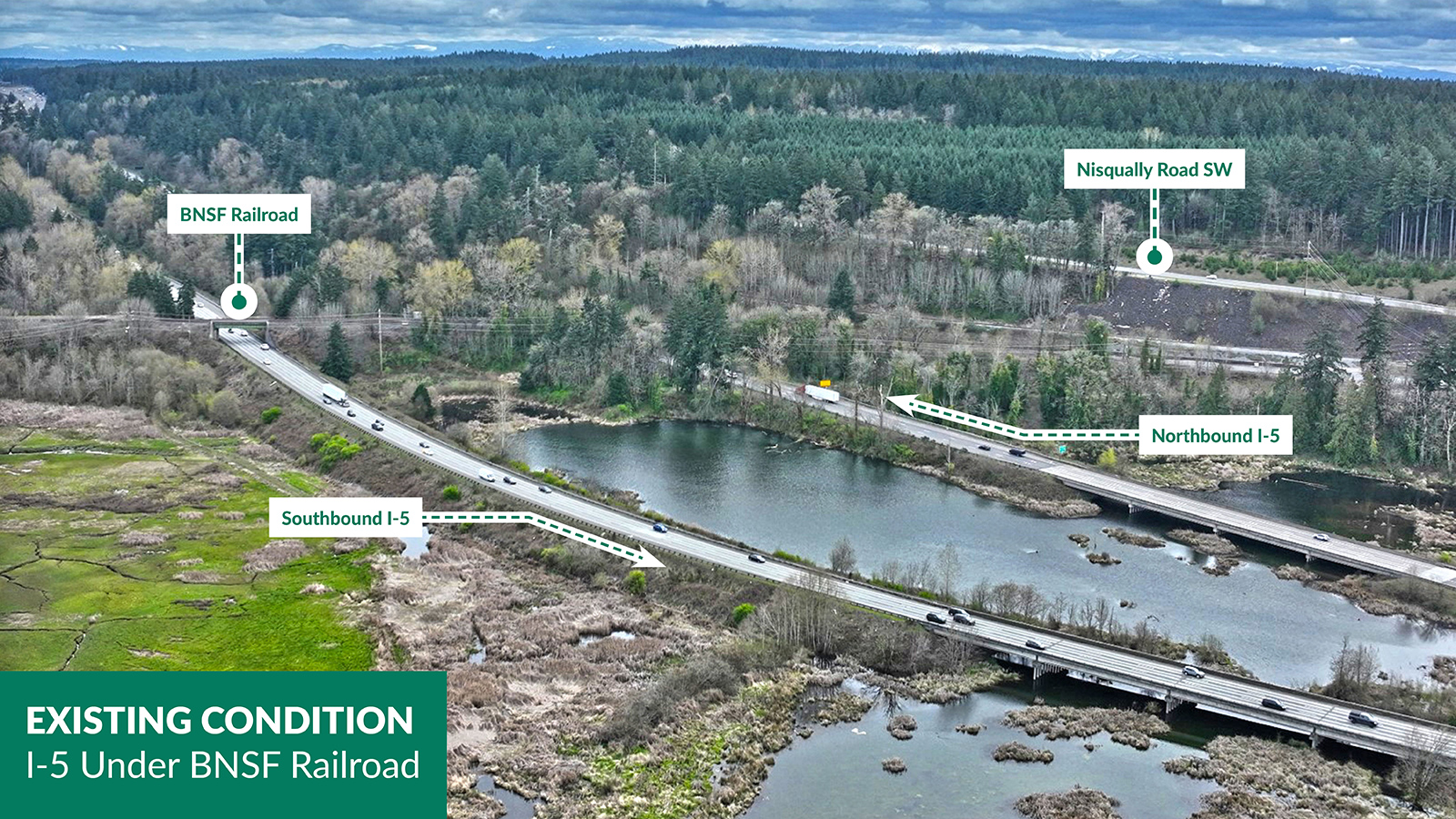
En esta propuesta se reconstruirían los puentes ferroviarios existentes formando un único puente que se extendería a lo largo de la I-5. Esta configuración requeriría la construcción de caballetes ferroviarios provisionales y muros de contención. Se tendrían que desplazar algunas vías del ferrocarril para que durante las obras, se mantuvieran las operaciones ferroviarias. El desvío ferroviario durante la construcción requeriría la tala de árboles y el trabajo temporal en humedales cercanos a la vía existente. Debido a estos impactos, el WSDOT ya no está considerando esta opción.
Reconducir el arroyo McAllister
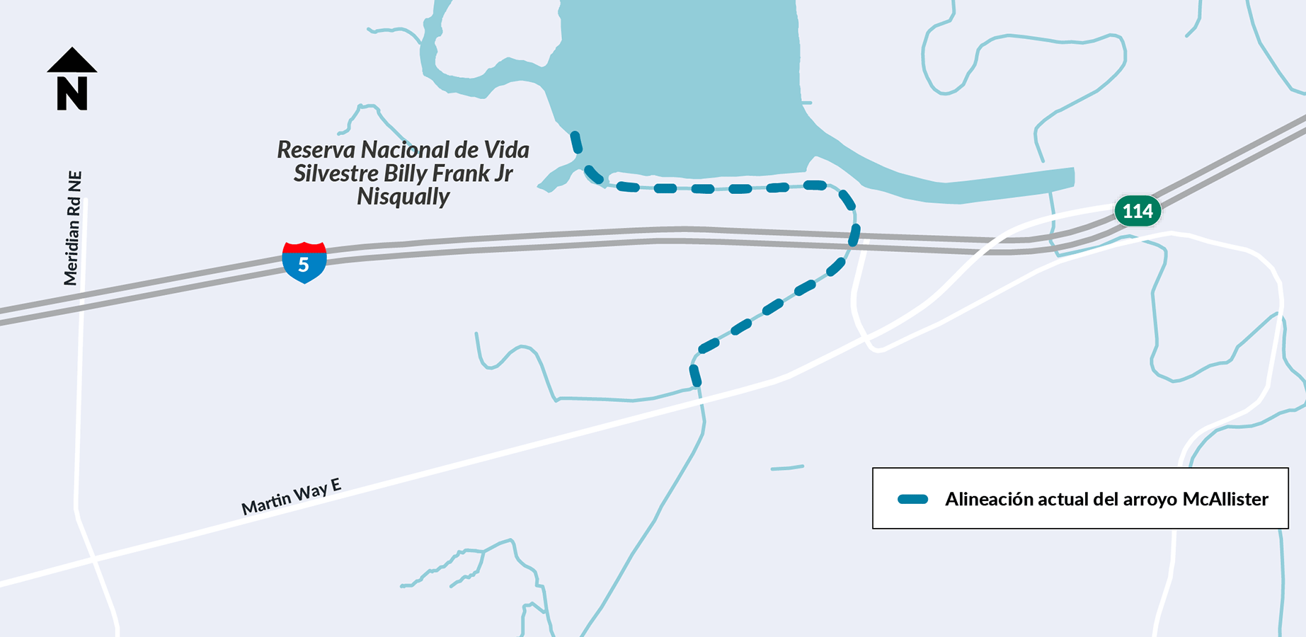
El proyecto propone reconducir el arroyo McAllister donde cruza por debajo de la I-5 para mejorar la calidad del agua y el hábitat.
El reajuste eliminaría la curva cerrada en la que la I-5 cruza actualmente el arroyo. Esto daría una nueva configuración al actual canal, muy inclinado y angosto. Esto permitirá que el agua del arroyo se mueva de forma más natural y favorecerá el crecimiento de humedales y plantas autóctonas. El WSDOT está trabajando con la tribu india Nisqually para desarrollar las mejoras propuestas.
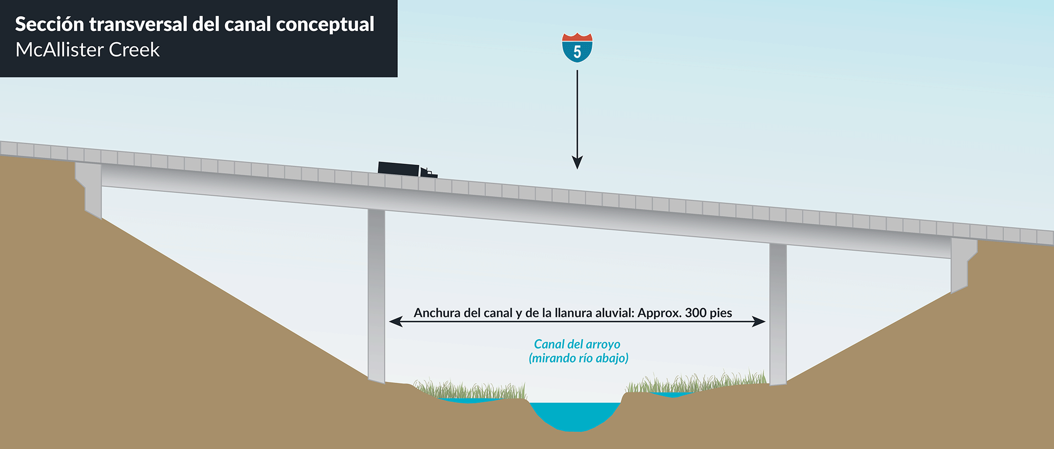
de anchura para el canal del arroyo y la llanura aluvial.
