SR 164 Vision and Implementation Plan

Share SR 164 Vision and Implementation Plan on Facebook Share SR 164 Vision and Implementation Plan on X (formerly Twitter) Share SR 164 Vision and Implementation Plan on Linkedin Email SR 164 Vision and Implementation Plan link

English | Español

Welcome!

Welcome to the State Route 164 Vision and Implementation Plan, Phase 2 online open house. WSDOT is studying SR 164 from Dogwood Street East in Auburn to High Point Street in Enumclaw. The study will help shape future anticipated improvements to this corridor. We want to hear what people need most along this route.

How to use this online open house

Use this open house to learn about the SR 164 Plan, see the plan timeline and share your feedback. You can go in order or skip to the sections that matter most to you.

About the study

Study Background

This section of SR 164 between Auburn and Enumclaw is an important roadway that helps connect people to their homes, schools, jobs, services, businesses and recreation. WSDOT is studying this part of SR 164 to create a vision and plan for future improvements. Because travel patterns and land use vary along the corridor, WSDOT is studying the corridor in four segments to better understand local conditions and identify potential changes for each area. The findings and recommendations from this study will be used to develop the SR 164 Vision and Implementation Plan, which will be submitted to the Washington State Legislature to help inform future transportation investments and decisions along the corridor.
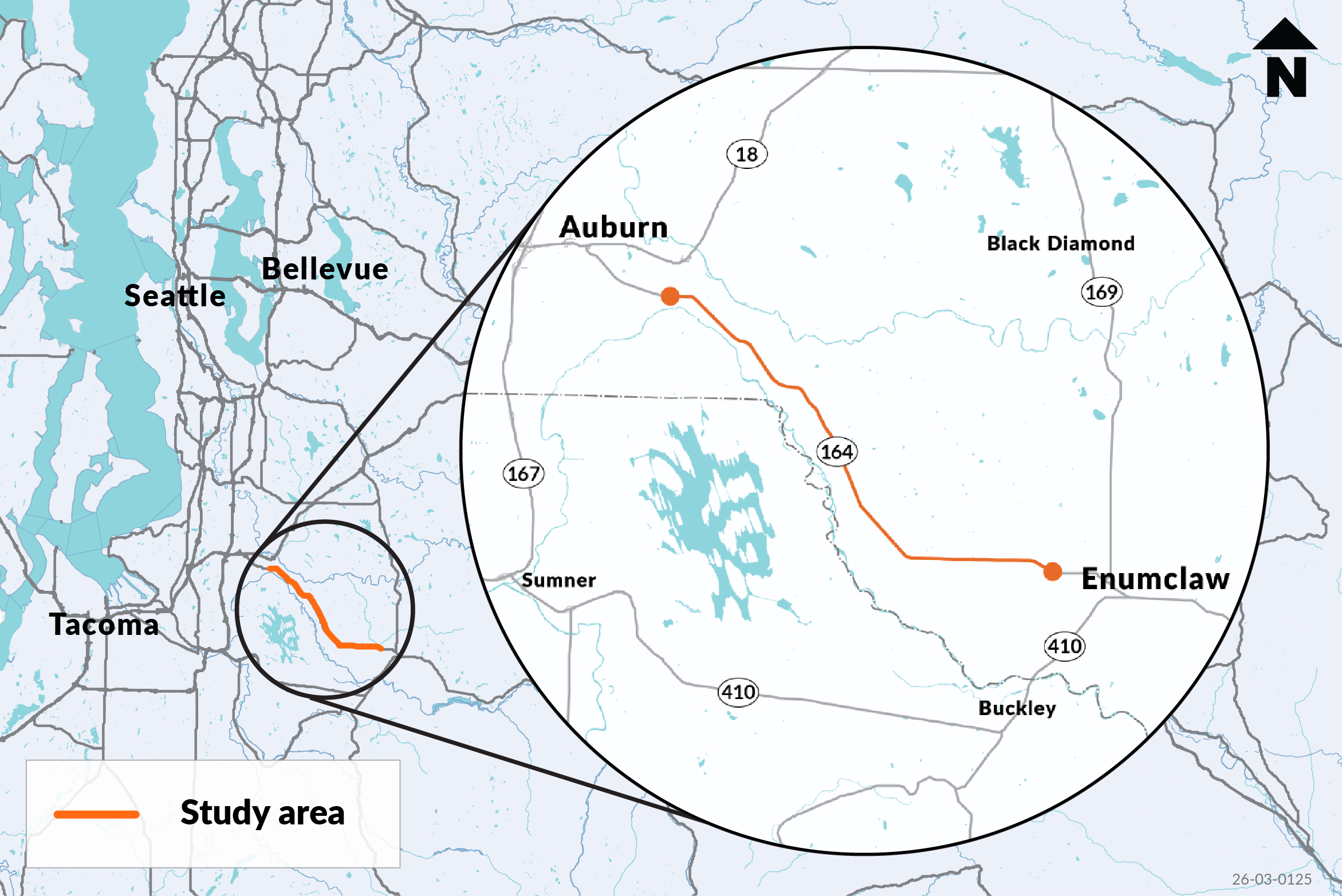
Regional map locating the SR 164 study area between Auburn and Enumclaw, southeast of Seattle.

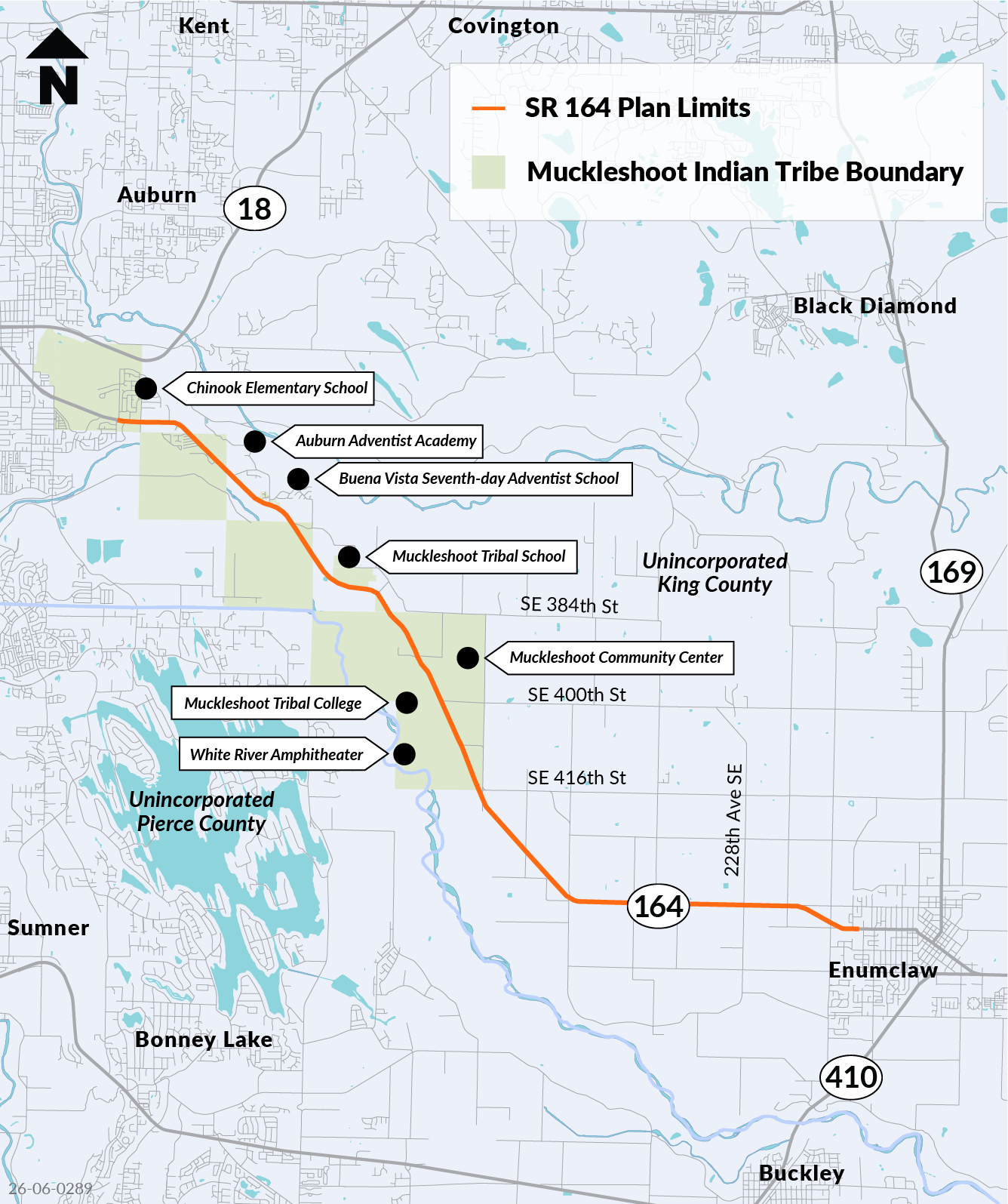
Map of the SR 164 study limits from Auburn to Enumclaw, showing the Muckleshoot Indian Tribe boundary and nearby schools and community destinations.

Why this study matters

Current conditions affect how people drive, walk, bike, roll, take transit and move goods between Auburn and Enumclaw.

Why WSDOT is studying SR 164

  • Parts of SR 164 are on the Puget Sound Regional Council High Injury Network. The High Injury Network identifies parts of the region's road network that have a higher density of traffic-related fatalities and serious injuries.
  • SR 164 connects homes, schools, jobs, services, businesses and recreation in Auburn, Enumclaw, King County and beyond.
  • This study supports WSDOT's mission to provide safe, reliable and cost-effective travel options and was funded by the 2025-2027 state budget.
  • The study looks at access, traffic flow, walking, biking, transit, freight and emergency response opportunities alongside safety performance.
  • Community input will help WSDOT understand local needs, compare investment options and shape future recommendations.

What this study can and cannot do

The study will identify short- and long-term options, document key opportunities and tradeoffs and recommend possible improvements. This is a planning study, not a construction project. Any future construction projects would still need funding, design, environmental review and ongoing coordination with partners and the community.

WSDOT has other work in the area including paving, construction, and an access study. If your question is about construction dates, lane closures, detours or another project, we will connect you with the right team. Other projects in the area include:

Partners in this area

WSDOT continues to work with partners in the corridor, including the Muckleshoot Indian Tribe, the cities of Auburn and Enumclaw, King County, King County Metro and other local and regional agencies. Input from our partners helps us align the study with local plans, transit needs, community priorities and emergency access.

Study process and timeline

What happens next

The study has three main parts: understand conditions, develop improvement options and prioritize options. WSDOT is currently in Phase 2. During this study, WSDOT is working with tribal governments, local governments, community members and subject matter experts so the recommendations reflect both local experience and technical expertise.

Phase 1 (done):

  • Collected data and reviewed current and future conditions, and listened to understand needs and concerns from residents, business owners and travelers.
  • Community input and partner input helped shape the study purpose, priorities and tradeoffs.

Phase 2 (we are here):

  • Based on input received during Phase 1, create improvement options for the corridor.
  • Review the improvement options. to compare the options and understand their benefits, limits and tradeoffs.
  • Share the different options with the community to gather input.

Phase 3:

  • Refine the recommendations. Share draft ideas, gather and apply feedback from the community and partners. Prioritize options. WSDOT shares draft recommendations and gathers input on which improvements might be done first, recognizing funding and legal limitations.
  • Finish the plan and report back. WSDOT will summarize what was heard, explain how input was used, and complete the plan for the State Legislature by June 30, 2027.

Timeline

  • Phase 1, spring to summer 2026
    Study current conditions and gather community input. This phase is complete.
  • Phase 2, late summer to fall 2026
    Develop options and refine them with public input. Our project is currently in this phase.
  • Phase 3, fall 2026 to early 2027
    Set priorities and complete the implementation plan.

How to participate

Online survey

During Phase 1 of this project, WSDOT gathered input through community events, virtual and in-person focus groups, and an online survey. More than 600 people shared their ideas and priorities. Thank you to everyone who took time to participate.

Community input, combined with technical analysis, helped shape a set of potential changes along SR 164. These concepts are meant to make travel more comfortable and reliable for all people, whether you drive, walk, bike, ride transit or move through the area in other ways.

Below, you will see locations for potential changes for four segments of SR 164 that were identified as part of Phase 1. Each segment includes labels and nearby cross streets to help you identify the location.

As you look at concepts and locations where we are considering changes, we want to hear what you think. Think about how the proposed changes may affect how you move through the area if they were built. Then share your feedback in the survey below. Your input will help us refine these concepts and shape the next phase of this study.
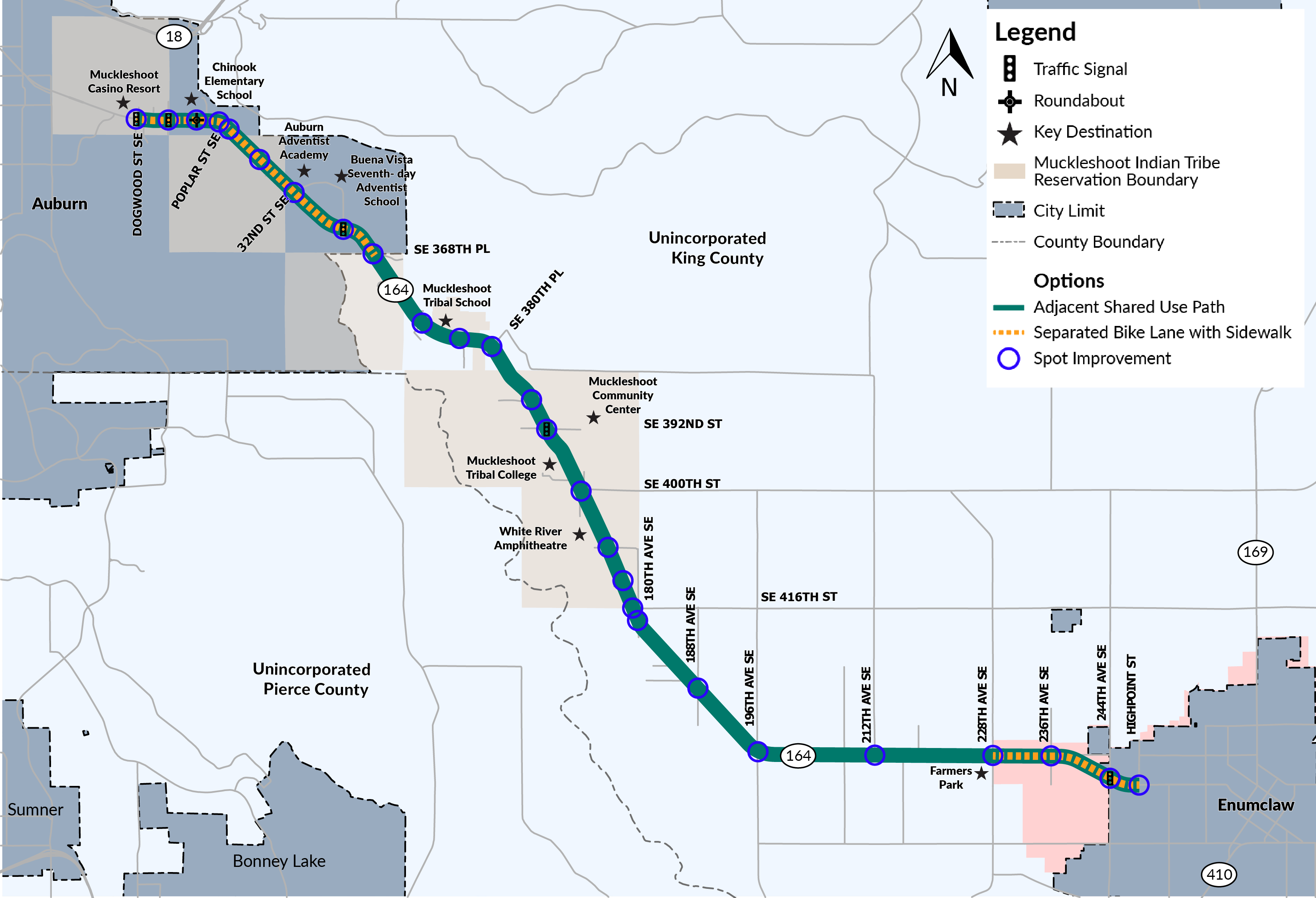
Corridor map from Auburn to Enumclaw showing proposed walking and biking route types and locations identified for spot improvements.

There are several types of options proposed for people walking, biking, and rolling along the study corridor. They include:

Adjacent shared-use path

  • Path along the roadway shared by people who walk, bike or use mobility devices
  • Comfortable and accessible path with separation from vehicle traffic
  • Potential pedestrian-bicycle conflicts and frequent driveway/intersection crossings
  • Common in rural areas and cities

Separated bicycle lane and sidewalk

  • Dedicated space for people who bike that is separated from traffic, with a separate sidewalk for people who walk or use mobility devices
  • Reduces bicycle-pedestrian conflicts while maintaining direct access to destinations
  • Less separation for people who bike from vehicle traffic and frequent driveway/intersection crossings
  • Common in cities

Off-corridor trail

  • Trail located away from the roadway in a separate corridor shared by people who walk, bike or use mobility devices
  • High comfort with minimal vehicle interaction
  • May be less direct to destinations
  • More common in rural areas

Here are some examples of each:
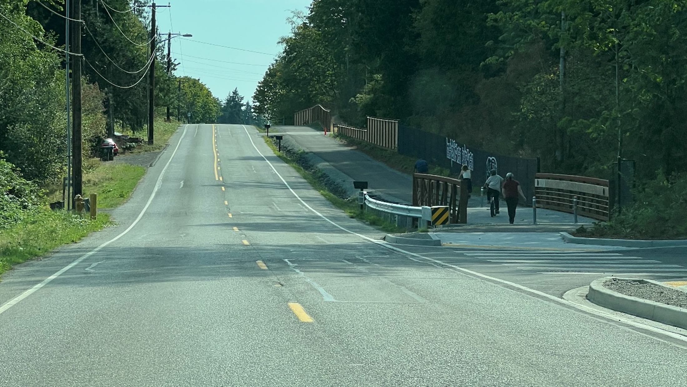
Two people walk on a paved path beside a road, separated from vehicle lanes by a roadside barrier.Figure 1: Example of an adjacent shared-use path
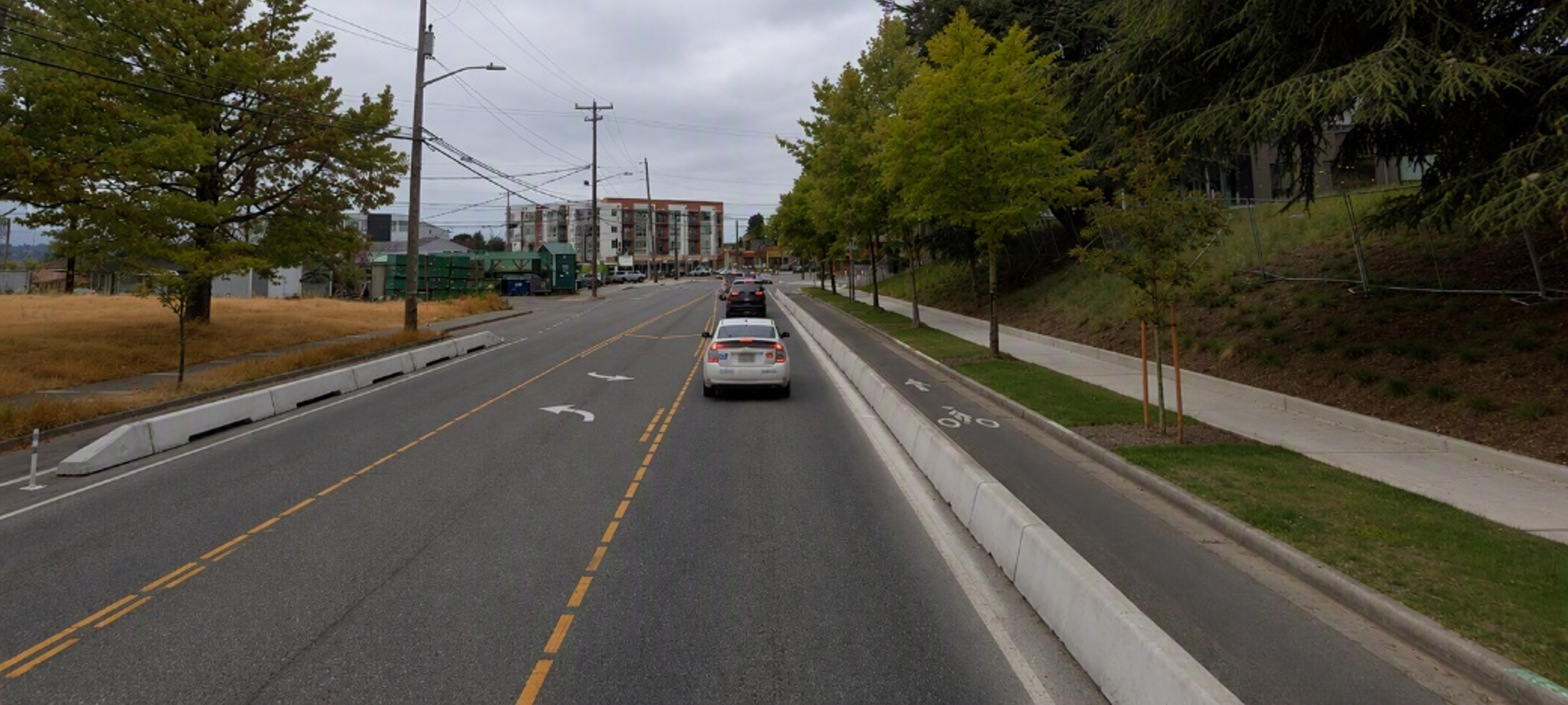
Street with a buffered bike lane beside the roadway and a separate sidewalk along the right side.Figure 2: Example of a separated bicycle lane and sidewalk
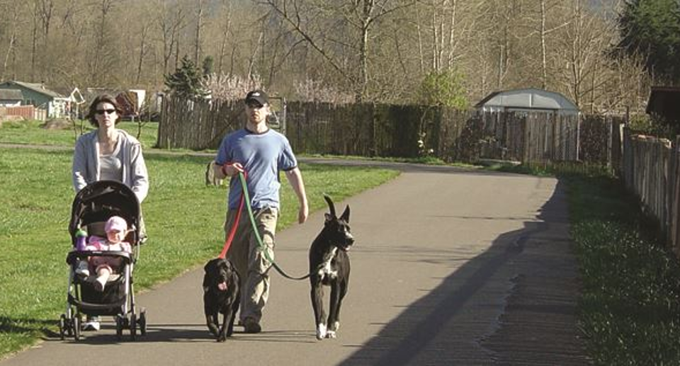

Two people walk with a stroller and dogs on a paved trail through a grassy area, away from the roadway as an example of an off-corridor trail.Figure 3: Example of an off-corridor trail

Stay involved

We appreciate everyone who has participated in the study so far. Your feedback is helping to inform recommendations that improve SR 164.

What's next

We will continue sharing updates and opportunities for you to stay involved throughout the study.

  • Fall 2026
    Online open house and survey
    In-person open house: Tuesday, October 20 at Chinook Elementary School. A Spanish interpreter will be available.
  • Winter 2026
    Review and comment on the draft Vision and Implementation Plan before it is finalized and shared with the Washington State Legislature.

Request a briefing

Would your neighborhood group, business, organization or community group like to learn more?

WSDOT offers free briefings to share project updates, answer questions and gather feedback. Contact Zack to schedule a presentation for your group.

Stay connected

Find project updates, engagement opportunities, meeting information, and study materials on the SR 164 Vision and Implementation Plan webpage.

Ways to participate:

  • Complete the survey.
  • Attend the in-person open house.
  • Request a briefing for your group or organization.
  • Review and comment on the draft plan (coming soon).
  • Sign up for information about study updates and future engagement opportunities.

Contact us

Questions or comments? Contact Zack Howard with questions or to share your feedback at zachary.howard@wsdot.wa.gov or 206-464-1253.

Need this information in another format or language? Let us know. We are committed to making project information accessible to everyone

English | Español

Welcome!

Welcome to the State Route 164 Vision and Implementation Plan, Phase 2 online open house. WSDOT is studying SR 164 from Dogwood Street East in Auburn to High Point Street in Enumclaw. The study will help shape future anticipated improvements to this corridor. We want to hear what people need most along this route.

How to use this online open house

Use this open house to learn about the SR 164 Plan, see the plan timeline and share your feedback. You can go in order or skip to the sections that matter most to you.

About the study

Study Background

This section of SR 164 between Auburn and Enumclaw is an important roadway that helps connect people to their homes, schools, jobs, services, businesses and recreation. WSDOT is studying this part of SR 164 to create a vision and plan for future improvements. Because travel patterns and land use vary along the corridor, WSDOT is studying the corridor in four segments to better understand local conditions and identify potential changes for each area. The findings and recommendations from this study will be used to develop the SR 164 Vision and Implementation Plan, which will be submitted to the Washington State Legislature to help inform future transportation investments and decisions along the corridor.

Regional map locating the SR 164 study area between Auburn and Enumclaw, southeast of Seattle.

Map of the SR 164 study limits from Auburn to Enumclaw, showing the Muckleshoot Indian Tribe boundary and nearby schools and community destinations.

Why this study matters

Current conditions affect how people drive, walk, bike, roll, take transit and move goods between Auburn and Enumclaw.

Why WSDOT is studying SR 164

  • Parts of SR 164 are on the Puget Sound Regional Council High Injury Network. The High Injury Network identifies parts of the region's road network that have a higher density of traffic-related fatalities and serious injuries.
  • SR 164 connects homes, schools, jobs, services, businesses and recreation in Auburn, Enumclaw, King County and beyond.
  • This study supports WSDOT's mission to provide safe, reliable and cost-effective travel options and was funded by the 2025-2027 state budget.
  • The study looks at access, traffic flow, walking, biking, transit, freight and emergency response opportunities alongside safety performance.
  • Community input will help WSDOT understand local needs, compare investment options and shape future recommendations.

What this study can and cannot do

The study will identify short- and long-term options, document key opportunities and tradeoffs and recommend possible improvements. This is a planning study, not a construction project. Any future construction projects would still need funding, design, environmental review and ongoing coordination with partners and the community.

WSDOT has other work in the area including paving, construction, and an access study. If your question is about construction dates, lane closures, detours or another project, we will connect you with the right team. Other projects in the area include:

Partners in this area

WSDOT continues to work with partners in the corridor, including the Muckleshoot Indian Tribe, the cities of Auburn and Enumclaw, King County, King County Metro and other local and regional agencies. Input from our partners helps us align the study with local plans, transit needs, community priorities and emergency access.

Study process and timeline

What happens next

The study has three main parts: understand conditions, develop improvement options and prioritize options. WSDOT is currently in Phase 2. During this study, WSDOT is working with tribal governments, local governments, community members and subject matter experts so the recommendations reflect both local experience and technical expertise.

Phase 1 (done):

  • Collected data and reviewed current and future conditions, and listened to understand needs and concerns from residents, business owners and travelers.
  • Community input and partner input helped shape the study purpose, priorities and tradeoffs.

Phase 2 (we are here):

  • Based on input received during Phase 1, create improvement options for the corridor.
  • Review the improvement options. to compare the options and understand their benefits, limits and tradeoffs.
  • Share the different options with the community to gather input.

Phase 3:

  • Refine the recommendations. Share draft ideas, gather and apply feedback from the community and partners. Prioritize options. WSDOT shares draft recommendations and gathers input on which improvements might be done first, recognizing funding and legal limitations.
  • Finish the plan and report back. WSDOT will summarize what was heard, explain how input was used, and complete the plan for the State Legislature by June 30, 2027.

Timeline

  • Phase 1, spring to summer 2026
    Study current conditions and gather community input. This phase is complete.
  • Phase 2, late summer to fall 2026
    Develop options and refine them with public input. Our project is currently in this phase.
  • Phase 3, fall 2026 to early 2027
    Set priorities and complete the implementation plan.

How to participate

Online survey

During Phase 1 of this project, WSDOT gathered input through community events, virtual and in-person focus groups, and an online survey. More than 600 people shared their ideas and priorities. Thank you to everyone who took time to participate.

Community input, combined with technical analysis, helped shape a set of potential changes along SR 164. These concepts are meant to make travel more comfortable and reliable for all people, whether you drive, walk, bike, ride transit or move through the area in other ways.

Below, you will see locations for potential changes for four segments of SR 164 that were identified as part of Phase 1. Each segment includes labels and nearby cross streets to help you identify the location.

As you look at concepts and locations where we are considering changes, we want to hear what you think. Think about how the proposed changes may affect how you move through the area if they were built. Then share your feedback in the survey below. Your input will help us refine these concepts and shape the next phase of this study.

Corridor map from Auburn to Enumclaw showing proposed walking and biking route types and locations identified for spot improvements.

There are several types of options proposed for people walking, biking, and rolling along the study corridor. They include:

Adjacent shared-use path

  • Path along the roadway shared by people who walk, bike or use mobility devices
  • Comfortable and accessible path with separation from vehicle traffic
  • Potential pedestrian-bicycle conflicts and frequent driveway/intersection crossings
  • Common in rural areas and cities

Separated bicycle lane and sidewalk

  • Dedicated space for people who bike that is separated from traffic, with a separate sidewalk for people who walk or use mobility devices
  • Reduces bicycle-pedestrian conflicts while maintaining direct access to destinations
  • Less separation for people who bike from vehicle traffic and frequent driveway/intersection crossings
  • Common in cities

Off-corridor trail

  • Trail located away from the roadway in a separate corridor shared by people who walk, bike or use mobility devices
  • High comfort with minimal vehicle interaction
  • May be less direct to destinations
  • More common in rural areas

Here are some examples of each:

Two people walk on a paved path beside a road, separated from vehicle lanes by a roadside barrier.Figure 1: Example of an adjacent shared-use path

Street with a buffered bike lane beside the roadway and a separate sidewalk along the right side.Figure 2: Example of a separated bicycle lane and sidewalk


Two people walk with a stroller and dogs on a paved trail through a grassy area, away from the roadway as an example of an off-corridor trail.Figure 3: Example of an off-corridor trail

Stay involved

We appreciate everyone who has participated in the study so far. Your feedback is helping to inform recommendations that improve SR 164.

What's next

We will continue sharing updates and opportunities for you to stay involved throughout the study.

  • Fall 2026
    Online open house and survey
    In-person open house: Tuesday, October 20 at Chinook Elementary School. A Spanish interpreter will be available.
  • Winter 2026
    Review and comment on the draft Vision and Implementation Plan before it is finalized and shared with the Washington State Legislature.

Request a briefing

Would your neighborhood group, business, organization or community group like to learn more?

WSDOT offers free briefings to share project updates, answer questions and gather feedback. Contact Zack to schedule a presentation for your group.

Stay connected

Find project updates, engagement opportunities, meeting information, and study materials on the SR 164 Vision and Implementation Plan webpage.

Ways to participate:

  • Complete the survey.
  • Attend the in-person open house.
  • Request a briefing for your group or organization.
  • Review and comment on the draft plan (coming soon).
  • Sign up for information about study updates and future engagement opportunities.

Contact us

Questions or comments? Contact Zack Howard with questions or to share your feedback at zachary.howard@wsdot.wa.gov or 206-464-1253.

Need this information in another format or language? Let us know. We are committed to making project information accessible to everyone

  • Tell us what you think about the proposed changes. Take this survey! Your input will help us better understand corridor needs, refine the study recommendations and inform the SR 164 Vision and Implementation Plan that will then be submitted to the Washington State Legislature.

    The survey is estimated to take about 10 minutes to complete and will be open through Monday, November 2, 2026. All responses are anonymous.

    Title VI notice to the public

    It is the Washington State Department of Transportation's (WSDOT) policy to assure that no person shall, on the grounds of race, color, national origin, as provided by Title VI of the Civil Rights Act of 1964, be excluded from participation in, be denied the benefits of, or be otherwise discriminated against under any of its programs and activities. Any person who believes his/her Title VI protection has been violated, may file a complaint with WSDOT's Office of Equity and Civil Rights (OECR). For additional information regarding Title VI complaint procedures and/or information regarding our non-discrimination obligations, please contact OECR's Title VI Coordinator at (360) 705-7090.

    Americans with Disabilities Act (ADA) information

    This material can be made available in an alternate format by emailing the Office of Equity and Civil Rights at wsdotada@wsdot.wa.gov or by calling toll free, 855-362-4ADA (4232). Persons who are deaf or hard of hearing may make a request by calling the Washington State Relay at 711.

    Translation information

    If you need this survey translated please contact the WSDOT Office of Equal Opportunity at 360-705-7090.

    Take Survey
    Share Survey (Phase 2) on Facebook Share Survey (Phase 2) on X (formerly Twitter) Share Survey (Phase 2) on Linkedin Email Survey (Phase 2) link
Page last updated: 12 Oct 2026, 03:57 PM