US 12 Packwood Planning Study and Online Community Engagement Survey

Share US 12 Packwood Planning Study and Online Community Engagement Survey on Facebook Share US 12 Packwood Planning Study and Online Community Engagement Survey on X (formerly Twitter) Share US 12 Packwood Planning Study and Online Community Engagement Survey on Linkedin Email US 12 Packwood Planning Study and Online Community Engagement Survey link

US 12 in Packwood provides an important connection to Mount Rainier National Park, White Pass and other year-round recreation destinations. During busy travel seasons, increased traffic and parking can lead to congestion and make it difficult for people to walk, bike, roll or move through the area.

WSDOT is studying potential transportation improvements along a 2-mile stretch of US 12 between Blakely Road and Turner Road. The study will look at traffic, parking, safety considerations and how people travel through Packwood today, as well as what may be needed in the future.

Share your thoughts

Why are we asking for your input?

Your feedback will help identify what works today, where there are challenges and what could work better.

This is the first of two opportunities to help shape the study:

1. Tell us what you need. This first online open house asks how you use US 12 today, what challenges you experience and what improvements are important to you.

2. See the options. The second online open house, planned for January 2027, will share potential improvements shaped by community feedback and study findings. You’ll have another opportunity to tell us what you think.

Survey feedback will be summarized and posted on the project webpage.

What will this study do?

The study will identify and recommend potential transportation improvements for US 12 through Packwood. Funding is currently available for the study, but not for design or construction.

The findings will help guide future projects and funding opportunities.

What happens next?

  • Fall 2026 – Tell us what you need
    Share how you use US 12, what challenges you experience and what could work better.
  • January 2027 – See the options
    Review potential improvements shaped by community feedback and study findings, then tell us what you think.
  • June 2027 – See the results
    Review the final study report and recommended improvements on the project webpage.

To learn more, visit the project webpage for information about Complete Streets, active transportation and previous planning work in Packwood.

Project Overview

The orange line on the map below shows the section of US 12 included in the study, between Blakely Road and Turner Road in Packwood.
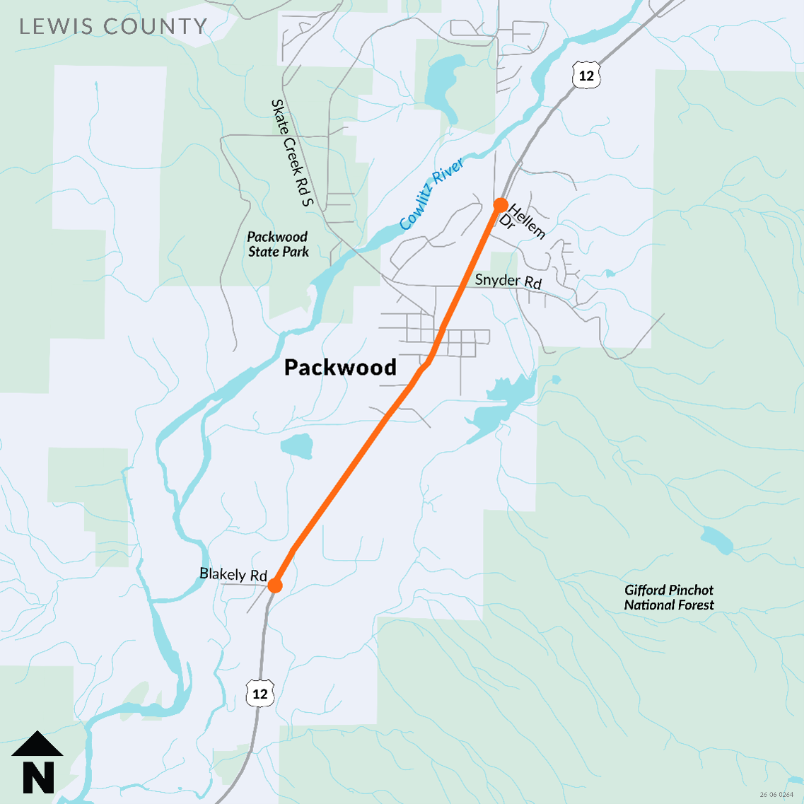
The US 12 Planning Study limits include US 12 between Blakely Road and Turner Road.Map of US 12 Planning Study Limits

Background

Lewis County’s planning for Packwood anticipates more homes and businesses in the community over time. As Packwood changes, more people will need to travel along and across US 12.

The Packwood Plan, adopted as part of the county’s Comprehensive Plan, identified US 12 as an important future connection for people walking and biking. While the plan identified broader transportation needs, it did not recommend specific improvements along the highway.

This study builds on that earlier planning work by taking a closer look at US 12 through Packwood. WSDOT will work with Lewis County, local partners and the community to understand transportation needs and identify potential improvements that make it safer and easier to travel through Packwood.
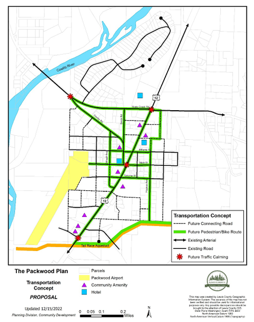
Map of the proposed transportation concept in The Packwood Plan. US 12 within the study limits is identified as a future pedestrian/bicycle route.Proposed Transportation Concept for Packwood. US 12 is identified as a future Pedestrian/Bicycle route.

Active Transportation

Active transportation includes walking, biking, rolling and using mobility devices to get where you need to go. Safe and connected sidewalks, crossings and bicycle routes can make it easier for people of all ages and abilities to travel through their community.

Why are these connections important in Packwood?

US 12 is both a highway and Packwood’s main street. Residents and visitors walk, bike and roll along or across the highway to reach businesses, services and other destinations.

During busy travel seasons, more vehicles and parked cars can make those trips challenging. This study will use a Complete Streets approach to look at where connections are missing or could be improved to make it safer and easier for people to get around Packwood.

What are Complete Streets?

Complete Streets consider the needs of everyone who uses the highway, including people who walk, bike, roll, use transit or drive. Improvements could include sidewalks, safer crossings, bicycle connections and other features that help people reach their destinations.

What kinds of improvements could be considered?

Potential improvements for people walking, biking and rolling could include:

  • Sidewalks – wider, accessible spaces separated from traffic where possible.
  • Accessible curb ramps – smoother connections at intersections and driveways.
  • Safer crossings – marked or raised crosswalks and flashing or signalized crossings.
  • Bicycle lanes – dedicated space for biking, with separation from traffic where possible.
  • Shared-use paths – wider paths separated from traffic for people walking, biking and rolling.

How do we look at walking and biking conditions?

Level of Traffic Stress, or LTS, is a way to measure how comfortable a roadway may be for people walking, biking or rolling.

Ratings range from LTS 1 to LTS 4. Lower ratings (LTS 1 or 2) generally indicate more comfortable conditions for people of different ages and abilities, while higher ratings (LTS 3 or 4) indicate more stressful conditions. WSDOT’s goal is LTS 2 or better for bicyclists and pedestrians, where possible.

Creating low-stress roads

Different roads may need different improvements to make walking, biking and rolling more comfortable. Options can include slower vehicle speeds and more separation between people and traffic.

The type of improvement depends on traffic speeds, the number of lanes and how much traffic uses the road. A busy, higher-speed road may need more separation, such as buffered or protected bicycle lanes and wider sidewalks. A lower-speed road with less traffic may need less separation.
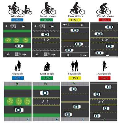
Examples of roadways rated LTS 1 through LTS 4 for bicyclists and pedestrians. LTS 1 and 2 roadways provide buffers and separation from vehicles, while LTS 3 and 4 do not. LTS 4 roadways may not have walking or biking facilities.Examples of roadways rated LTS 1 through LTS 4. Note the connection between the amount of separation from traffic and the LTS rating.

What is the Level of Traffic Stress on US 12?

US 12 through Packwood has a posted speed limit of 35 mph, carries fewer than 3,000 vehicles a day and does not currently have dedicated sidewalks or bicycle connections.

Based on these conditions and traffic volumes, US 12 through Packwood is rated LTS 4 for walking and biking, the highest level of traffic stress. This means the roadway may feel uncomfortable or difficult for many people walking, biking or rolling.

This study will look at potential improvements that could create lower-stress connections through Packwood.

US 12 in Packwood provides an important connection to Mount Rainier National Park, White Pass and other year-round recreation destinations. During busy travel seasons, increased traffic and parking can lead to congestion and make it difficult for people to walk, bike, roll or move through the area.

WSDOT is studying potential transportation improvements along a 2-mile stretch of US 12 between Blakely Road and Turner Road. The study will look at traffic, parking, safety considerations and how people travel through Packwood today, as well as what may be needed in the future.

Share your thoughts

Why are we asking for your input?

Your feedback will help identify what works today, where there are challenges and what could work better.

This is the first of two opportunities to help shape the study:

1. Tell us what you need. This first online open house asks how you use US 12 today, what challenges you experience and what improvements are important to you.

2. See the options. The second online open house, planned for January 2027, will share potential improvements shaped by community feedback and study findings. You’ll have another opportunity to tell us what you think.

Survey feedback will be summarized and posted on the project webpage.

What will this study do?

The study will identify and recommend potential transportation improvements for US 12 through Packwood. Funding is currently available for the study, but not for design or construction.

The findings will help guide future projects and funding opportunities.

What happens next?

  • Fall 2026 – Tell us what you need
    Share how you use US 12, what challenges you experience and what could work better.
  • January 2027 – See the options
    Review potential improvements shaped by community feedback and study findings, then tell us what you think.
  • June 2027 – See the results
    Review the final study report and recommended improvements on the project webpage.

To learn more, visit the project webpage for information about Complete Streets, active transportation and previous planning work in Packwood.

Project Overview

The orange line on the map below shows the section of US 12 included in the study, between Blakely Road and Turner Road in Packwood.

The US 12 Planning Study limits include US 12 between Blakely Road and Turner Road.Map of US 12 Planning Study Limits

Background

Lewis County’s planning for Packwood anticipates more homes and businesses in the community over time. As Packwood changes, more people will need to travel along and across US 12.

The Packwood Plan, adopted as part of the county’s Comprehensive Plan, identified US 12 as an important future connection for people walking and biking. While the plan identified broader transportation needs, it did not recommend specific improvements along the highway.

This study builds on that earlier planning work by taking a closer look at US 12 through Packwood. WSDOT will work with Lewis County, local partners and the community to understand transportation needs and identify potential improvements that make it safer and easier to travel through Packwood.

Map of the proposed transportation concept in The Packwood Plan. US 12 within the study limits is identified as a future pedestrian/bicycle route.Proposed Transportation Concept for Packwood. US 12 is identified as a future Pedestrian/Bicycle route.

Active Transportation

Active transportation includes walking, biking, rolling and using mobility devices to get where you need to go. Safe and connected sidewalks, crossings and bicycle routes can make it easier for people of all ages and abilities to travel through their community.

Why are these connections important in Packwood?

US 12 is both a highway and Packwood’s main street. Residents and visitors walk, bike and roll along or across the highway to reach businesses, services and other destinations.

During busy travel seasons, more vehicles and parked cars can make those trips challenging. This study will use a Complete Streets approach to look at where connections are missing or could be improved to make it safer and easier for people to get around Packwood.

What are Complete Streets?

Complete Streets consider the needs of everyone who uses the highway, including people who walk, bike, roll, use transit or drive. Improvements could include sidewalks, safer crossings, bicycle connections and other features that help people reach their destinations.

What kinds of improvements could be considered?

Potential improvements for people walking, biking and rolling could include:

  • Sidewalks – wider, accessible spaces separated from traffic where possible.
  • Accessible curb ramps – smoother connections at intersections and driveways.
  • Safer crossings – marked or raised crosswalks and flashing or signalized crossings.
  • Bicycle lanes – dedicated space for biking, with separation from traffic where possible.
  • Shared-use paths – wider paths separated from traffic for people walking, biking and rolling.

How do we look at walking and biking conditions?

Level of Traffic Stress, or LTS, is a way to measure how comfortable a roadway may be for people walking, biking or rolling.

Ratings range from LTS 1 to LTS 4. Lower ratings (LTS 1 or 2) generally indicate more comfortable conditions for people of different ages and abilities, while higher ratings (LTS 3 or 4) indicate more stressful conditions. WSDOT’s goal is LTS 2 or better for bicyclists and pedestrians, where possible.

Creating low-stress roads

Different roads may need different improvements to make walking, biking and rolling more comfortable. Options can include slower vehicle speeds and more separation between people and traffic.

The type of improvement depends on traffic speeds, the number of lanes and how much traffic uses the road. A busy, higher-speed road may need more separation, such as buffered or protected bicycle lanes and wider sidewalks. A lower-speed road with less traffic may need less separation.

Examples of roadways rated LTS 1 through LTS 4 for bicyclists and pedestrians. LTS 1 and 2 roadways provide buffers and separation from vehicles, while LTS 3 and 4 do not. LTS 4 roadways may not have walking or biking facilities.Examples of roadways rated LTS 1 through LTS 4. Note the connection between the amount of separation from traffic and the LTS rating.

What is the Level of Traffic Stress on US 12?

US 12 through Packwood has a posted speed limit of 35 mph, carries fewer than 3,000 vehicles a day and does not currently have dedicated sidewalks or bicycle connections.

Based on these conditions and traffic volumes, US 12 through Packwood is rated LTS 4 for walking and biking, the highest level of traffic stress. This means the roadway may feel uncomfortable or difficult for many people walking, biking or rolling.

This study will look at potential improvements that could create lower-stress connections through Packwood.

  • Take Survey
    Share US 12 Packwood Planning Study Survey on Facebook Share US 12 Packwood Planning Study Survey on X (formerly Twitter) Share US 12 Packwood Planning Study Survey on Linkedin Email US 12 Packwood Planning Study Survey link
Page last updated: 30 Sep 2026, 01:13 PM