English | Español
Welcome
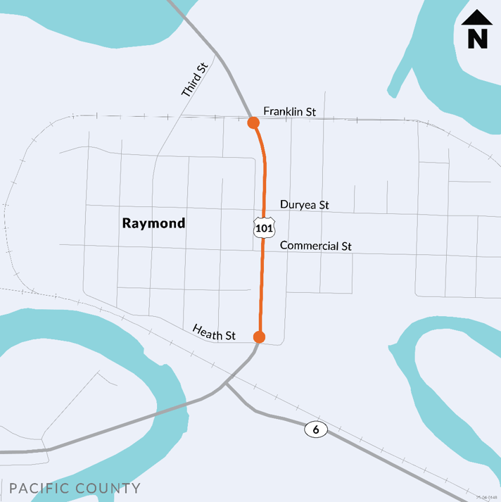
The Washington State Department of Transportation is studying the US 101 corridor (section of the highway) through Raymond between Heath Street and Franklin Street to identify ways to make the road safer and more comfortable for people walking, biking, using assistive devices, or using transit.
In this online open house, we’ll explain why we’re studying this part of the US 101 corridor. We’ll also go over what the area looks like today and ask for your ideas on how we can make it better for everyone who uses the road. This online open house is open through June 25.
Why are we studying this corridor?
Community concerns
WSDOT is studying this corridor for bike and pedestrian improvements because of safety community concerns about crossing US 101. Some of the complaints received included concerns with traffic not yielding to pedestrians at the unsignalized crosswalks and the need for safe routes to school. We have also received reports of drivers continuing southbound on US 101 in the right turn lane past Heath Street, where the highway narrows to one lane leading into the US 101/SR 6 roundabout.
Local agency policies
The City of Raymond is interested in promoting and improving mobility and connectivity for people walking, biking or using assistive devices. In the City’s Comprehensive Plan, the following goals relate to this project:
- Maintain existing transportation infrastructure and services that meet the residential and economic needs of the community.
- Design and implement safe and efficient transportation improvements that are consistent with the goals and policies of the land-use element. Facilitate pedestrian and bicycle improvements to improve facility connectivity within the city and regional facilities to promote and increase physical activity of citizens.
Future projects
There are a couple of projects proposed within the study corridor that this study would support. The city is a recipient of a WSDOT Active Transportation Assistance Program grant to support design for a future Safe Routes to School project on Duryea Street. This would connect the residential and commercial areas west of US 101 with the schools and residences east of US 101 and north on US 105. This project would design bicycle and pedestrian improvements on Duryea Street, including the crossing at the intersection of US 101 and Duryea. In the future, WSDOT will be paving US 101 between the Niawiakum Bridge and Franklin Street. This paving project gives us a chance to make low-cost improvements that we find in this corridor plan.
Level of traffic stress
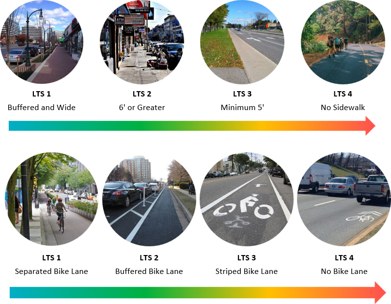
When studying bicycle and pedestrian improvements, WSDOT uses the Level of Traffic Stress, or LTS, metric. Level of Traffic Stress is a measure of user comfort when walking, biking or using assistive devices on a given corridor.
LTS ratings are based on the following characteristics:
- Number of travel lanes on the roadway
- Traffic volumes
- Posted speed (or Target speed when comparing different improvements)
- The amount of separation provided between motorists and active transportation users
The higher the LTS rating, the less comfortable an improvement is for those walking, biking or using assistive devices. The graphic below provides examples of what differently rated areas look like. For WSDOT projects, the goal is to meet LTS 2 or better for bicyclists and pedestrians.