Hello! Thanks for taking the time to complete this study survey.
People use SR 900 for many reasons, and we want to know how to create a corridor that works for your needs and priorities!
Your answers will help us understand what works best for you and your neighbors and will help us develop the recommended improvement options for the corridor.
In this survey, the term “corridor” is used to describe the roadway being redesigned, along SR 900 from 57th Avenue South to South 135th Street.
Phase A: SR 900 Corridor Improvements
Phase A is divided into five segments:
- Segment 1: 57th Avenue South to South 129th Street
- Segment 2: South 129th Street to 64th Avenue South
- Segment 3: 64th Avenue South to South 133rd Street
- Segment 4: South 133rd Street to 68th Avenue South
- Segment 5: 68th Avenue South to South 135th Street
Next, we will walk through different design options for each segment of Phase A.
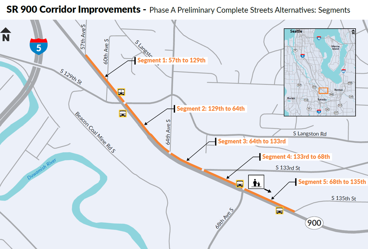 Figure 8: A map of the project area showing SR 900 divided into five segments.
Segment 1: SR 900 between 57th Avenue South and South 129th Street
This segment is from 57th Street South to South 129th Street. The surrounding area is primarily residential with some commercial use and businesses closer to South 129th Street. There is a steep drop-off on the south side of SR 900 with dense tree coverage.
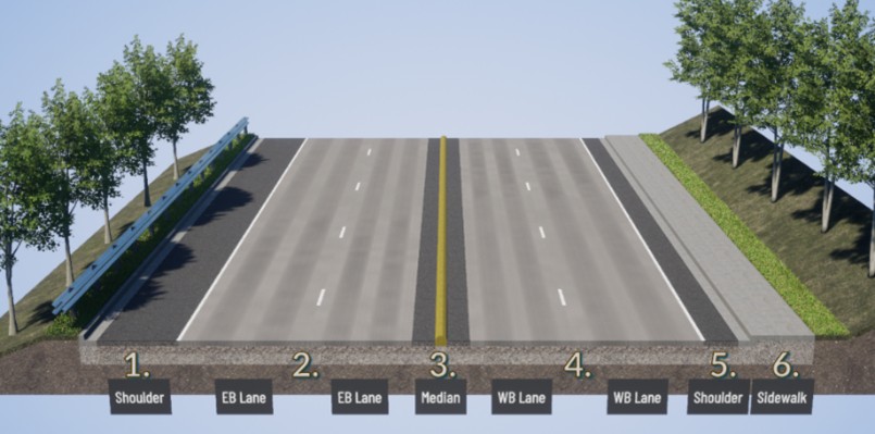 Figure 9: A cross section showing the existing conditions of SR 900 between 57th Avenue South and South 129th Street.
Segment 1 Existing Conditions Legend:
- Shoulder – Varying width up to 8 feet, providing storage for emergency stopping
- Two eastbound lanes heading towards Skyway and Renton
- Median raised curb – 1-foot-wide traffic curb separating eastbound and westbound travel lanes
- Two westbound lanes heading toward I-5 and Seattle
- Shoulder – Varying width up to 4 feet, providing storage for emergency stopping
- Sidewalk – 5-foot-wide walkway for pedestrians
The first alternative removes roadway shoulders to accommodate the new buffered shared-use-path on the westbound side of SR 900. For a future sidewalk on the eastbound side, construction into the steep drop off would be needed.
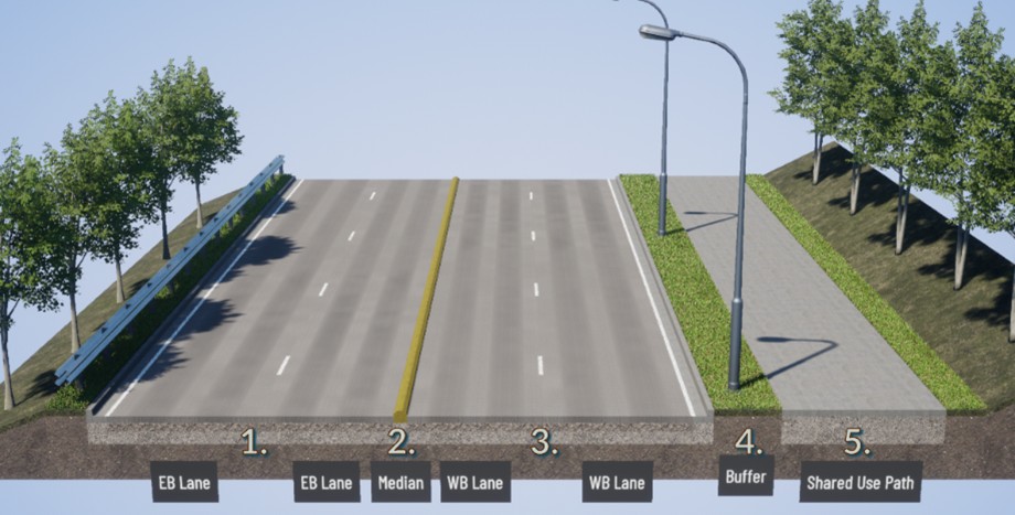 Figure 10: Preliminary Alternative 1 would keep two lanes in each direction and includes a raised traffic curb between eastbound and westbound SR 900, and the shared use path on westbound SR 900.
Segment 1 Preliminary Alternative 1 Legend:
- Two eastbound lanes heading towards Skyway and Renton
- Median raised curb – 1-foot-wide traffic curb separating eastbound and westbound travel lanes
- Two westbound lanes heading toward I-5 and Seattle
- Buffer – 5-foot-wide landscaping, providing lighting and separation for from travel lanes
- Shared Use Path – 12-foot-wide walkway for pedestrians and bicyclists
The second alternative removes one westbound lane and reduces roadway shoulder width to accommodate the new buffered shared-use-path. Preliminary traffic analysis shows traffic congestion will look similar to existing conditions. The eastbound shoulder would be replaced with sidewalk in a future phase. This alternative avoids impacts to the steep drop-off.
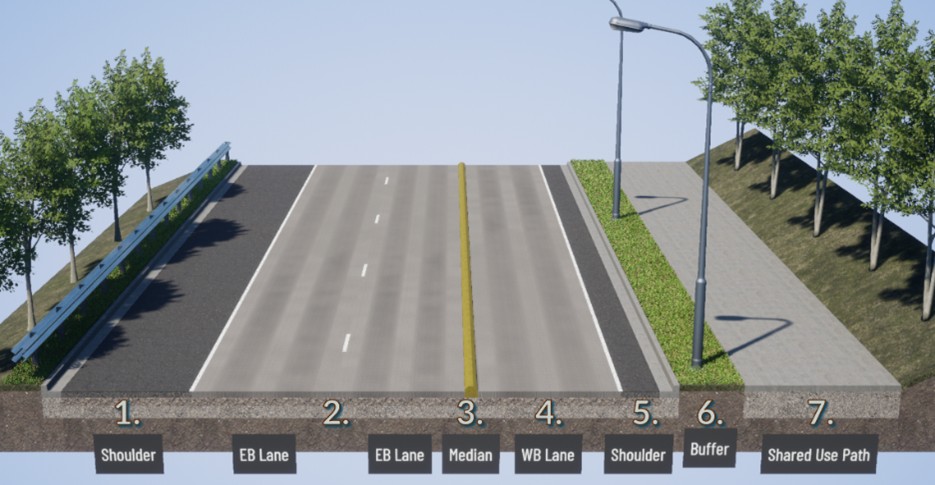 Figure 11: Preliminary Alternative 2 removes one westbound lane and includes a raised traffic curb between eastbound and westbound SR 900, a shoulder and buffer between the shared use path and westbound SR 900.
Segment 1 Preliminary Alternative 2 Legend:
- Shoulder – Varying width up to 10 feet, reserved for Phase C - eastbound sidewalk and buffer.
- Two eastbound lanes heading towards Skyway and Renton
- Median raised curb – 1-foot-wide traffic curb separating eastbound and westbound travel lanes
- One westbound lane heading toward I-5 and Seattle
- Shoulder – Varying width up to 2 feet
- Buffer – 5-foot-wide landscaping, providing lighting and separation for from travel lanes
- Shared Use Path – 12-foot-wide walkway for pedestrians and bicyclists
Unlike the following segments (2 – 5), the first segment only has two alternatives under consideration due to the large traffic volumes on eastbound SR 900 coming from I-5 in the afternoon peak hour.
For segment 1, what do you dislike and like about Alternative 1, and Alternative 2?
Segment 2: SR 900 between South 129th Street and 64th Avenue South
This segment is from South 129th Street to 64th Avenue South. The surrounding area has a mix of residential areas on both sides of SR 900 and industrial use on the south side of SR 900. There is a small hill on the north side of SR 900 with moderate tree coverage.
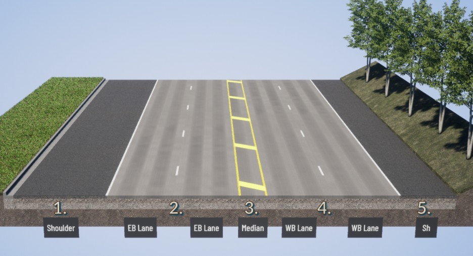 Figure 12: A cross section showing the existing conditions of SR 900 between South 129th Street and 64th Avenue South. Both eastbound and westbound SR 900 have paved shoulders and no active transportation facilities.
Segment 2 Existing Conditions Legend:
- Shoulder – Varying width up to 15 feet, providing storage for emergency stopping and parking
- Two eastbound lanes heading towards Skyway and Renton
- Painted median – Varying width separating eastbound and westbound travel lanes
- Two westbound lanes heading toward I-5 and Seattle
- Shoulder – Varying width up to 8 feet, providing storage for emergency stopping
The first alternative removes roadway shoulders and the existing median to accommodate the new buffered shared-use-path on the westbound side of SR 900. The eastbound shoulder would be replaced with sidewalk in a future phase.
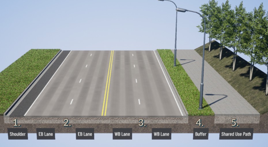 Figure 13: Preliminary Alternative 1 would keep two lanes in each direction but remove the striped median between eastbound and westbound lanes to allow for a wide buffer between the roadway and the shared use path on westbound SR 900.
Segment 2 Preliminary Alternative 1 Legend:
- Shoulder – Varying width.
- Two eastbound lanes heading towards Skyway and Renton
- Two westbound lanes heading toward I-5 and Seattle
- Buffer – 5-foot-wide landscaping, providing lighting and separation for from travel lanes
- Shared Use Path – 12-foot-wide walkway for pedestrians and bicyclists
The second alternative removes one westbound lane, the existing median, and removes the westbound roadway shoulder to accommodate the new buffered shared-use-path. Preliminary traffic analysis shows traffic congestion will look similar to existing conditions. The eastbound shoulder would be replaced with sidewalk in a future phase.
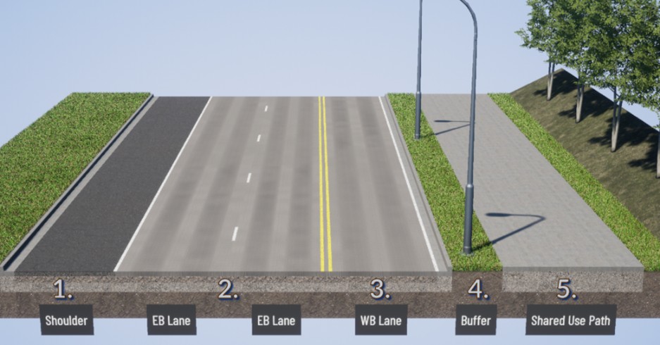 Figure 14: Preliminary Alternative 2 removes one westbound lane and includes a raised median and wide shoulder on the east side, a raised median between SR 900 eastbound and westbound and a buffer between the shared use path and westbound SR 900.
Segment 2 Preliminary Alternative 2 Legend:
- Shoulder – Varying width, reserved for Phase C - eastbound sidewalk and buffer
- Two eastbound lanes heading towards Skyway and Renton
- One westbound lane heading toward I-5 and Seattle
- Buffer – 5-foot-wide landscaping, providing lighting and separation for from travel lanes
- Shared Use Path – 12-foot-wide walkway for pedestrians and bicyclists
The third alternative removes one westbound lane, one eastbound lane, the existing median, and reduces roadway shoulder width to accommodate the new buffered shared-use-path. Preliminary traffic analysis shows traffic congestion will look similar to existing conditions. The eastbound shoulder would be replaced with sidewalk in a future phase.
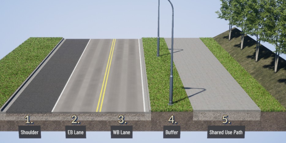 Figure 15: Preliminary Alternative 3 removes one lane in each direction and includes a raised median between eastbound and westbound SR 900, a raised median and wide shoulder on the east side and wider buffer between the shared use path and SR 900.
Segment 2 Preliminary Alternative 3 Legend:
- Shoulder – Varying width, reserved for Phase C - eastbound sidewalk and buffer
- One eastbound lane heading toward Skyway and Renton
- One westbound lane heading toward I-5 and Seattle
- Buffer – Varying width landscaping, providing lighting and separation for from travel lanes
- Shared Use Path – 12-foot-wide walkway for pedestrians and bicyclists
For Segment 2, what do you dislike and like about Alternative 1, Alternative 2, and Alternative 3?
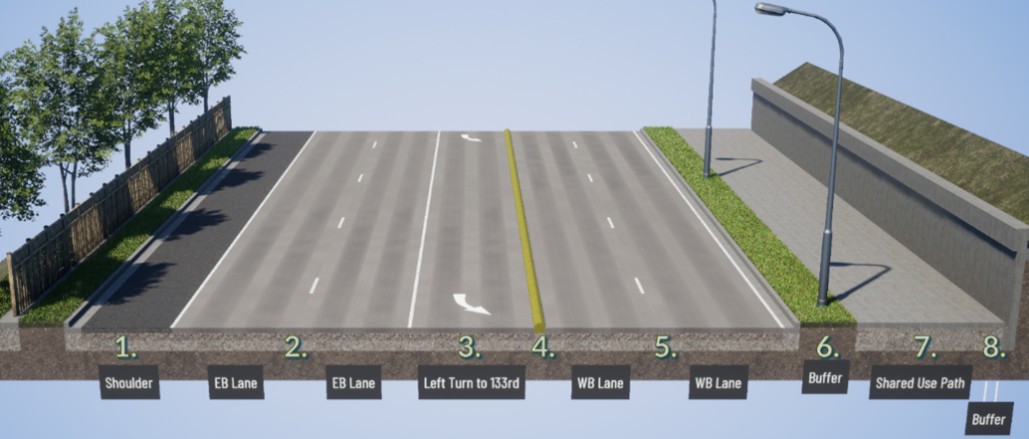
Segment 3: SR 900 between 64th Avenue South and South 133rd Street
This segment is from 64th Avenue South to South 133rd Street. The surrounding area is residential on the north side of SR 900 on top of the steep hill and industrial on the south side of SR 900. There is a steep drop-off with a fence on the south side of SR 900 and a steep hill on the north side. Both sides have dense tree coverage.
 Figure 16: Shows the existing conditions of SR 900 between 64th Avenue South and South 133rd Street.
Segment 3 Existing Conditions Legend:
- Shoulder – Varying width up to 8 feet, providing storage for emergency stopping
- Two eastbound lanes heading towards Skyway and Renton
- Eastbound left-turn lane to 133rd Street
- Median raised curb – 1-foot-wide traffic curb separating eastbound and westbound travel lanes
- Two westbound lanes heading toward I-5 and Seattle
- Shoulder – Varying width up to 4 feet
The first alternative removes the westbound roadway shoulder to accommodate the new buffered shared-use-path on the westbound side of SR 900. This alternative requires a retaining wall for construction into the steep hill. The eastbound shoulder would be replaced with sidewalk in a future phase.
 Preliminary Alternative 1 keeps the same number of lanes and would require digging into the hillside to construct a retaining wall.
Segment 3 Preliminary Alternative 1 Legend:
- Shoulder – Varying width, reserved for Phase C - eastbound sidewalk and buffer
- Two eastbound lanes heading towards Skyway and Renton
- Eastbound left-turn lane to 133rd Street
- Median raised curb – 1-foot-wide traffic curb separating eastbound and westbound travel lanes
- Two westbound lanes heading toward I-5 and Seattle
- Buffer – 5-foot-wide landscaping, providing lighting and separation for from travel lanes
- Shared Use Path – 12-foot-wide walkway for pedestrians and bicyclists
- Buffer – Additional shared use path width next to the retaining wall
The second alternative removes one westbound lane and the westbound roadway shoulder to accommodate the new buffered shared-use-path. This alternative requires a retaining wall for construction into the steep hill. Preliminary traffic analysis shows traffic congestion will look similar to existing conditions. The eastbound shoulder would be replaced with sidewalk in a future phase.
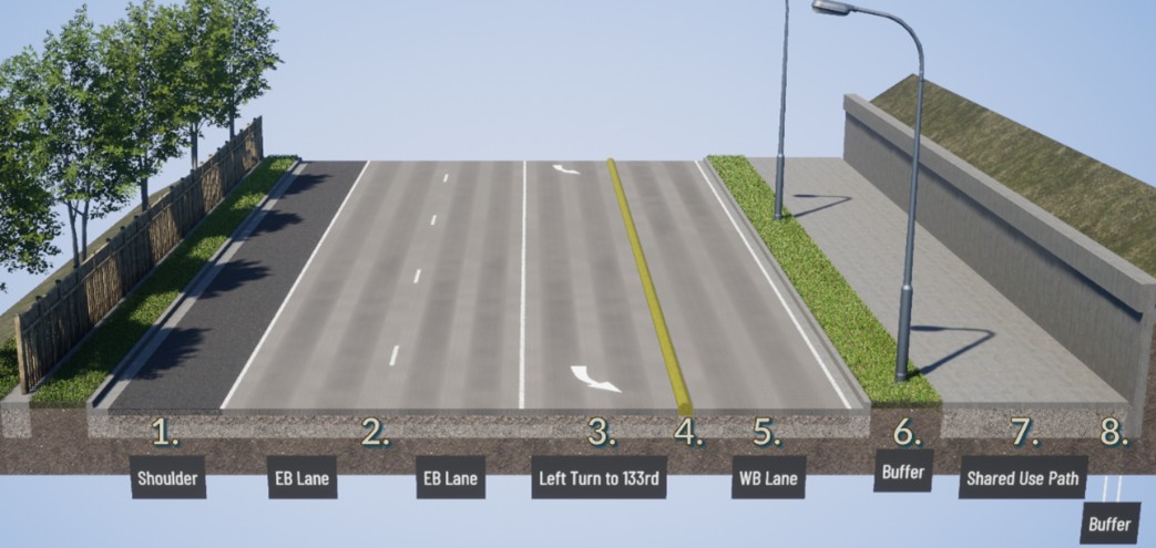 Figure 18: Preliminary Alternative 2 would remove a westbound lane and include raised traffic curb between eastbound and westbound SR 900, a raised median and buffer between the shared use path and westbound SR 900. This would require digging into the hillside to build a retaining wall.
Segment 3 Preliminary Alternative 2 Legend:
- Shoulder – Varying width, reserved for Phase C - eastbound sidewalk and buffer.
- Two eastbound lanes heading towards Skyway and Renton
- Eastbound left-turn lane to 133rd Street
- Median raised curb – 1-foot-wide traffic curb separating eastbound and westbound travel lanes
- One westbound lane heading toward I-5 and Seattle
- Buffer – 5-foot-wide landscaping, providing lighting and separation for from travel lanes
- Shared Use Path – 12-foot-wide walkway for pedestrians and bicyclists
- Buffer – Additional shared use path width next to the retaining wall
The third alternative removes one westbound lane, one eastbound lane, the existing median, and westbound roadway shoulder to accommodate the new buffered shared-use-path. Preliminary traffic analysis shows traffic congestion will look similar to existing conditions. The eastbound shoulder would be replaced with sidewalk in a future phase. Early assessments indicate a retaining wall is likely not needed.
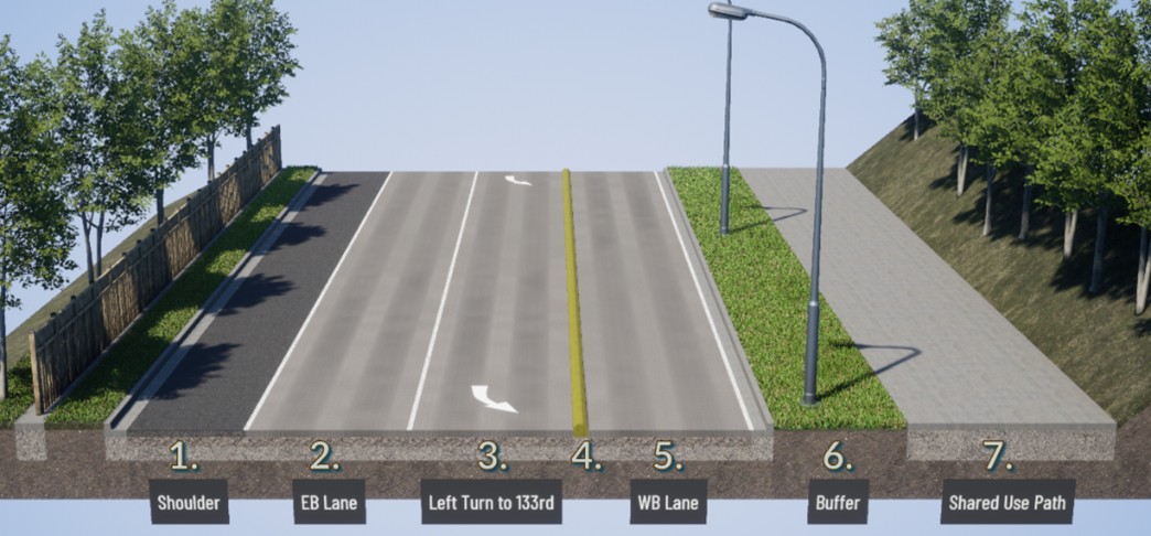 Figure 19: Preliminary Alternative 3 would remove one lane in each direction and include raised traffic curb between eastbound and westbound SR 900, a raised median and buffer between the shared use path and westbound SR 900. This would likely not require digging into the hillside to construct a retaining wall.
Segment 3 Preliminary Alternative 3 Legend:
- Shoulder – Varying width, reserved for Phase C - eastbound sidewalk and buffer
- One eastbound lane heading toward Skyway and Renton
- Eastbound left-turn lane to 133rd Street
- Median raised curb – 1-foot-wide traffic curb separating eastbound and westbound travel lanes
- One westbound lane heading toward I-5 and Seattle
- Buffer – 5-foot-wide landscaping, providing lighting and separation for from travel lanes
- Shared Use Path – 12-foot-wide walkway for pedestrians and bicyclists
For Segment 3, what do you dislike and like about Alternative 1, Alternative 2, and Alternative 3?
Segment 4: SR 900 between South 133rd Street and 68th Avenue South
This segment is from South 133rd Street to 68th Avenue South. The surrounding area is residential on the north side of SR 900. There is a steep drop-off on the south side of SR 900 with a guardrail and a ditch on the north side. Both sides have moderate tree coverage.
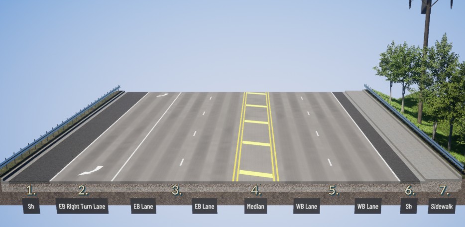 Figure 20: Shows the existing conditions of SR 900 between South 133rd Street and 68th Avenue South.
Segment 4 Existing Conditions Legend:
- Shoulder – Varying width up to 8 feet, providing storage for emergency stopping
- Eastbound right-turn lane to 68th Avenue South
- Two eastbound lanes heading towards Skyway and Renton
- Painted median – Varying width separating eastbound and westbound travel lanes
- Two westbound lanes heading toward I-5 and Seattle
- Shoulder – Varying width up to 4 feet
- Sidewalk – 5-foot-wide walkway for pedestrians
The first alternative removes roadway shoulders and raises the existing median (details to be determined) to accommodate the new buffered shared-use-path on the westbound side of SR 900. The eastbound shoulder would be replaced with sidewalk in a future phase.
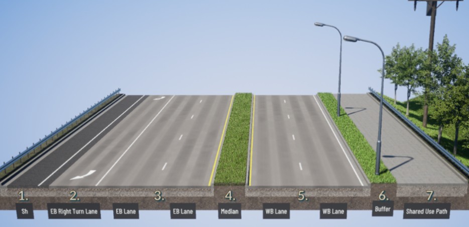 Figure 21: Preliminary Alternative 1 would keep the same number of lanes and include a buffer with a shared use path on the south side.
Segment 4 Preliminary Alternative 1 Legend:
- Shoulder – Varying width, reserved for Phase C - eastbound sidewalk and buffer
- Eastbound right-turn lane to 68th Avenue South
- Two eastbound lanes heading towards Skyway and Renton
- Raised Median – Varying width, separating eastbound and westbound travel lanes
- Two westbound lanes heading toward I-5 and Seattle
- Buffer – 5-foot-wide landscaping, providing lighting and separation for from travel lanes
- Shared Use Path – 12-foot-wide walkway for pedestrians and bicyclists
The second alternative removes one westbound lane, raises the existing median (details to be determined), and removes the westbound roadway shoulder to accommodate the new buffered shared-use-path. Preliminary traffic analysis shows traffic congestion will look similar to existing conditions. The eastbound shoulder would be replaced with sidewalk in a future phase.
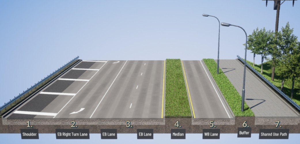 Figure 22: Preliminary Alternative 2 removes a westbound lane, includes a median between the eastbound and westbound lanes, as well as a buffer separating the shared use path from the highway.
Segment 4 Preliminary Alternative 2 Legend:
- Shoulder – Varying width, reserved for Phase C - eastbound sidewalk and buffer
- Eastbound right-turn lane to 68th Avenue South
- Two eastbound lanes heading toward Skyway and Renton
- Raised Median – Varying width, separating eastbound and westbound travel lanes
- One westbound lane heading toward I-5 and Seattle
- Buffer – 5-foot-wide landscaping, providing lighting and separation for from travel lanes
- Shared Use Path – 12-foot-wide walkway for pedestrians and bicyclists
The third alternative removes one westbound lane, one eastbound lane, raises the existing median (details to be determined), and removes the westbound roadway shoulder to accommodate the new buffered shared-use-path. Preliminary traffic analysis shows current traffic volumes will function similar to existing conditions. The eastbound shoulder would be replaced with sidewalk in a future phase.
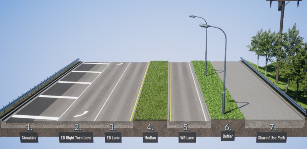 Figure 23: Preliminary Alternative 3 removes one lane in each direction to create space for a wider shoulder on the northside, a median between the east- and westbound lanes and a buffered area between the highway and the shared use path.
Segment 4 Preliminary Alternative 3 Legend:
- Shoulder – Varying width, reserved for Phase C - eastbound sidewalk and buffer
- Eastbound right-turn lane to 68th Avenue South
- One eastbound lane heading toward Skyway and Renton
- Raised Median – Varying width, separating eastbound and westbound travel lanes
- One westbound lane heading toward I-5 and Seattle
- Buffer – 5-foot-wide landscaping, providing lighting and separation for from travel lanes
- Shared Use Path – 12-foot-wide walkway for pedestrians and bicyclists
For Segment 4, what do you dislike and like about Alternative 1, Alternative 2, and Alternative 3?
Segment 5: SR 900 between 68th Avenue South and South 135th Street
This segment is from 68th Avenue South to South 135th Street. The surrounding area is residential on both sides of SR 900. There are two large apartment complexes on the south side of SR 900, and moderate tree coverage and vegetation. There is a ditch on the north side of SR 900 until the Ukrainian Community Center parking lot joins SR 900.
 Figure 24: A cross section showing existing conditions of SR 900 between 68th Avenue South and South 135th Street.
Segment 5 Existing Conditions Legend:
- Sidewalk – 5-foot-wide walkway for pedestrians
- Shoulder – Varying width up to 8 feet, providing storage for emergency stopping
- Two eastbound lanes heading towards Skyway and Renton
- Two-Way Left-Turn Lane
- Two westbound lanes heading toward I-5 and Seattle
- Shoulder – Varying width up to 8 feet, adjacent to the private parking
The first alternative removes roadway shoulders to accommodate the new buffered shared-use-path on the westbound side of SR 900. The shared-use-path would be separated from the parking lot with a raised-concrete buffer. The eastbound shoulder would be replaced with buffer space in a future phase to separate the sidewalk from the roadway.
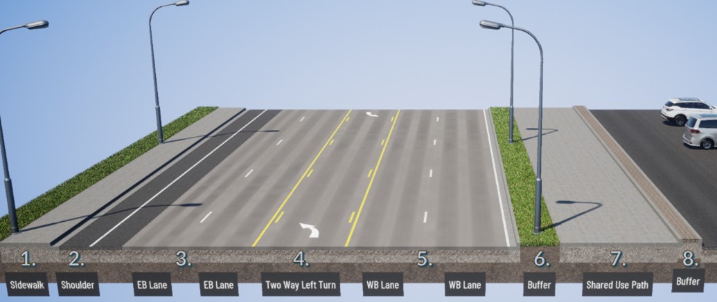 Figure 25: Preliminary Alternative 1 would keep two lanes in each direction but removes shoulder space to allow for a wider buffer between the roadway and the shared use path.
Segment 5 Preliminary Alternative 1 Legend:
- Sidewalk – 5-foot-wide walkway for pedestrians
- Shoulder – Varying width up to 4 feet
- Two eastbound lanes heading towards Skyway and Renton
- Two-Way Left-Turn Lane
- Two westbound lanes heading toward I-5 and Seattle
- Buffer – 5-foot-wide landscaping, providing lighting and separation for from travel lanes
- Shared Use Path – 12-foot-wide walkway for pedestrians and bicyclists
- Buffer – 2-foot-wide concrete buffer, providing separation from adjacent parking lot
The second alternative removes one westbound lane and removes the westbound roadway shoulder to accommodate the new buffered shared-use-path. Preliminary traffic analysis shows traffic congestion will look similar to existing conditions. The shared-use-path would be separated from the parking lot with a raised-concrete buffer. The eastbound shoulder would be replaced with buffer space in a future phase to separate the sidewalk from the roadway.
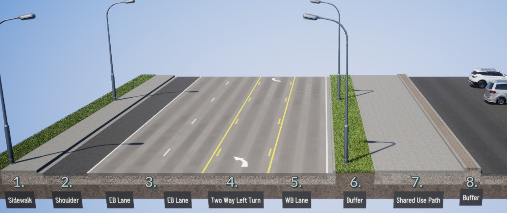 Figure 26: Preliminary Alterative 2 removes the westbound lane and retains a wide shoulder on the south side, as well as a buffer between the shared use path and the highway.
Segment 5 Preliminary Alternative 2 Legend:
- Sidewalk – 5-foot-wide walkway for pedestrians
- Shoulder – Varying width up to 8 feet
- Two eastbound lanes heading towards Skyway and Renton
- Two-Way Left-Turn Lane
- One westbound lane heading toward I-5 and Seattle
- Buffer – 5-foot-wide landscaping, providing lighting and separation for from travel lanes
- Shared Use Path – 12-foot-wide walkway for pedestrians and bicyclists
- Buffer – 2-foot-wide concrete buffer, providing separation from adjacent parking lot
The third alternative removes one westbound lane, one eastbound lane and removes the westbound roadway shoulder to accommodate the new buffered shared-use-path. Preliminary traffic analysis shows traffic congestion will look similar to existing conditions. The shared-use-path could be separated from the parking lot with a landscaped buffer. The eastbound shoulder would be replaced with buffer space in a future phase to separate the sidewalk from the roadway.
 Figure 27: Preliminary Alterative 3 removes one lane in each direction to retain space for shoulders on both sides, and a buffered area between the highway and the shared use path.
Segment 5 Preliminary Alternative 3 Legend:
- Sidewalk – 5-foot-wide walkway for pedestrians
- Shoulder – Varying width up to 8 feet
- One eastbound lane heading toward Skyway and Renton
- Two-Way Left-Turn Lane
- One westbound lane heading toward I-5 and Seattle
- Buffer – 5-foot-wide landscaping, providing lighting and separation for from travel lanes
- Shoulder – Varying width up to 4 feet
- Shared Use Path – 12-foot-wide walkway for pedestrians and bicyclists
- Buffer – Varying width landscaping providing separation from private parking lot
For Segment 5, what do you dislike and like about Alternative 1, Alternative 2, and Alternative 3?
Phase B: SR 900 Corridor Improvements
WSDOT has heard concerns from previous community engagement particularly about vehicle speeds in the corridor. In 2024, WSDOT lowered the speed limits on SR 900 between 129th Street South and 135th Street South as an initial step to mitigate speeds. However, other traffic calming measures such as roundabouts and lane narrowing are under consideration as part of an overall speed management strategy.
To improve traffic flow and reduce speeds, intersection improvements are being considered at SR 900 and 129th Street and at SR 900 and 135th Street South. Currently, these improvements are unfunded, but it is important to identify solutions that would be compatible with Phase A, should funding become available.
SR 900 / 129th Street South
Options under consideration:
- Improved traffic signal – Modifications to reduce the potential for crashes
- Roundabout – Lower traffic speeds, reduce the potential for crashes, and create community gateway
- Peanut Roundabout – Lower traffic speeds, reduce the potential for crashes, create community gateway and minimize potential footprint
SR 900 / 135th Street South
Options under consideration:
- Improved unsignalized intersection – Modifications to reduce the potential for crashes
- Roundabout –Lower traffic speeds and reduce the potential for crashes
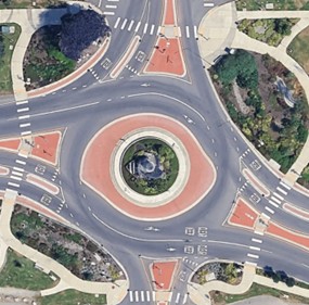 Figure 28: Example of a two-lane
roundabout. Kent, WA.
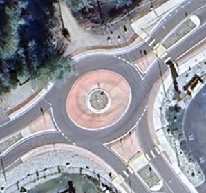 Figure 29: Example of a single lane
roundabout. Leavenworth, WA
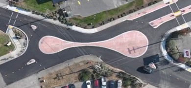 Figure 26: Example of a peanut roundabout.
Lake Stevens, WA
For Phase B, what do you dislike and like about Option 1, Option 2, and Option 3 at SR 900 / 129th Street South?
For Phase B, what do you dislike and like about Option 1, Option 2, and Option 3 at SR 900 / 135th Street South?