Background
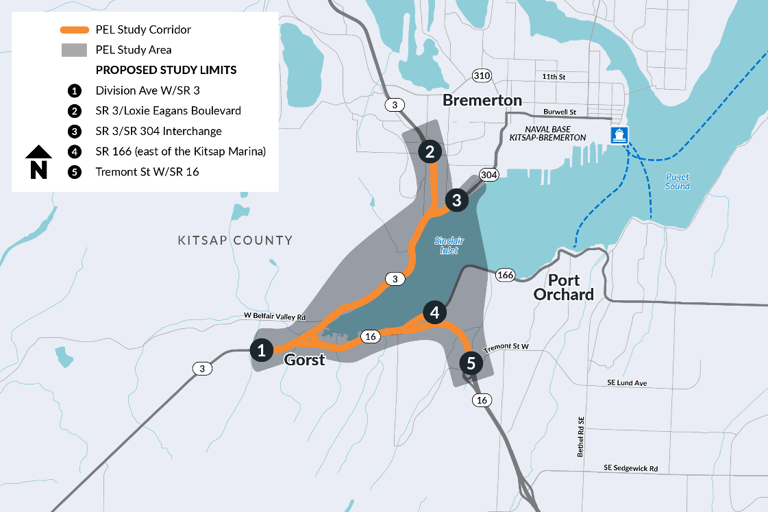
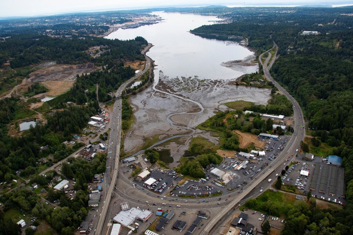
The study centers on Gorst, an unincorporated community in Kitsap County. SR 3 and SR 16 meet in Gorst, and congestion on these highways affects the entire region.
The two highways are the only land-based state routes to northern Kitsap County. SR 3 is the main access route for Kitsap County and is an important connection to the Hood Canal Bridge and the Olympic Peninsula.
The area is also a key hub for connection to the cities of Belfair and Shelton (via SR 3), Port Orchard (via SR 166) and Bremerton (via SR 304).
Bremerton is home to Naval Base Kitsap-Bremerton, the Navy’s third largest fleet concentration in the United States. The Base connects to SR 3 via SR 304. SR 3 also serves more Department of Defense facilities north of Bremerton. This makes each highway important for matters of national security. The roads were built in 1964, and they do not meet current standards to withstand seismic activity such as earthquakes and tsunamis. The roads are also susceptible to natural disasters and effects of climate change such as sea level rise.
There are many factors to consider when developing transportation and environmental solutions in this area. Local community concerns include congestion, safety, access, and resiliency.
Funding
The Washington State Legislature committed $75 million of state and federal funding over several years. The funding covers the PEL Study and National Environmental Policy Act (NEPA) process(es), right-of-way acquisition, and preliminary design. There is currently no construction funding identified.
Timeline
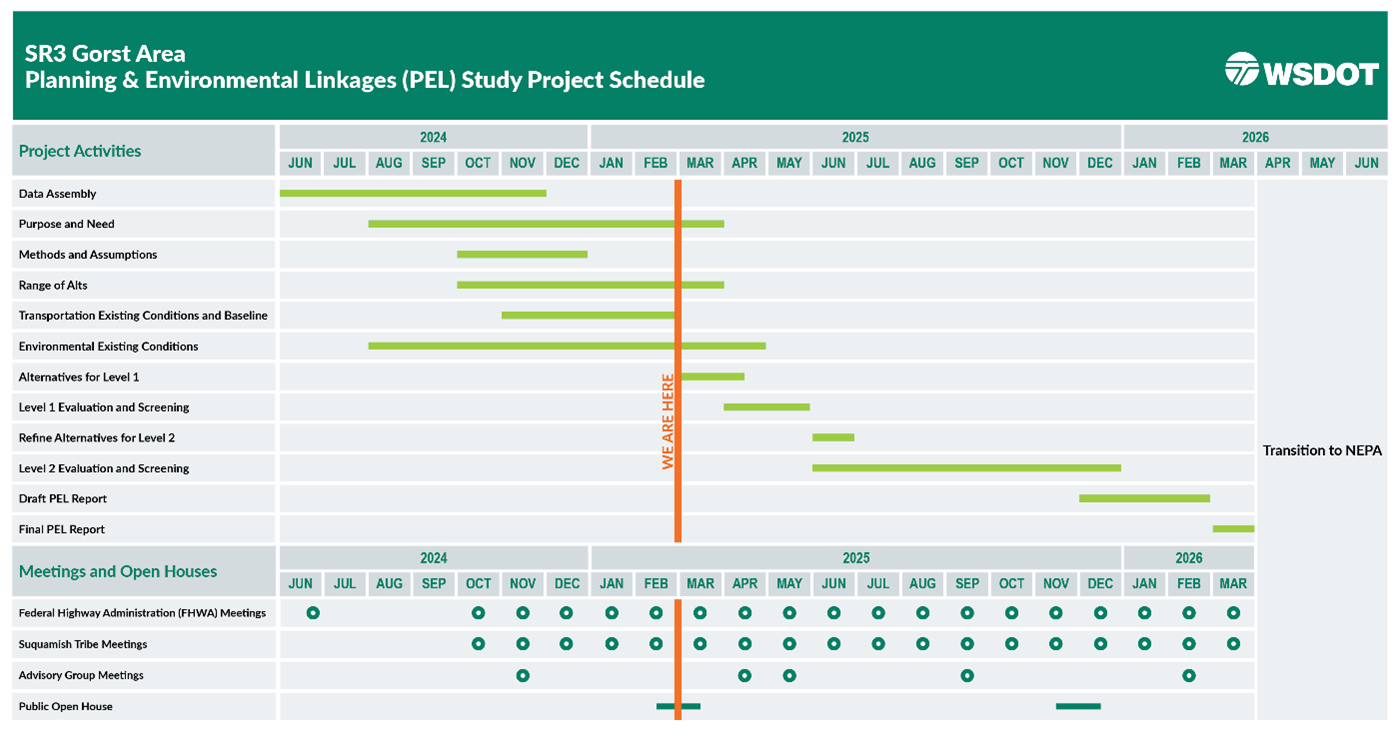
WSDOT initiated the PEL phase in June 2024 and expects to be complete by March 2026. WSDOT will continue to engage advisory groups and the public throughout the study.
Overview of PEL process
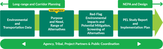
WSDOT is conducting the SR 3 Gorst Area PEL Study in partnership with the Federal Highway Administration (FHWA). A PEL study is a collaborative approach to transportation decision-making. This approach outlines environmental, community, and economic goals early in the transportation planning process.
As part of the PEL study, WSDOT is actively engaging with tribal nations, local governments, transit and resource agencies, and vulnerable populations and overburdened communities in the study area. This early engagement will help WSDOT identify a purpose and need, analyze a range of multimodal alternatives, and examine the potential environmental impacts of those alternatives.
Following a PEL process ensures WSDOT is studying potential environmental benefits and impacts early in the project delivery process. This approach helps to build a strong foundation with the public and partners, get to know the community’s concerns early, and helps to scope future projects and prioritize needs and funding.
The desired outcomes of this PEL study are to:
- Define the purpose and need for improvements.
- Develop and screen alternatives.
- Develop an implementation plan that recommends the timing and scope of projects recommended as part of this study.
It should be noted that this PEL study is following a (regulatory) process that will allow the purpose and need and alternatives to be revisited in the environmental phase. However, the steps we are taking today will ensure that we are aware of important considerations we must make once we transition into the NEPA phase.
Engagement during PEL
Community and partner engagement is a critical part of the PEL process. Input from the community and study partners will inform the SR 3 Gorst Area PEL study. WSDOT is engaging the public, vulnerable populations and overburdened communities, and community-based organizations (CBOs). We are also engaging federal, state and local agencies, and active transportation and transit groups. Tribal nations are a key audience, specifically the Suquamish and Skokomish Tribes. Their traditional lands include the Kitsap Peninsula.
WSDOT is convening community, executive, and technical advisory groups during the PEL study. Meeting recordings will be made available within ten days of advisory group meetings on the study website.
There are several ways to get involved during the PEL study. WSDOT will invite groups for briefings and present at in-person meetings in the community. We also plan to host neighborhood pop-up events and in-person and online open houses, like this one.
What we’re studying during PEL
WSDOT identified key focus areas for the study through early exploration of transportation and environmental existing conditions, reviewing previous studies, and collecting new data. Consultation with the Suquamish Tribe and Skokomish Indian Tribe also informed these focus areas.
Below shows existing conditions and what the study team is reviewing in the Purpose and Need
This PEL study builds on previous transportation studies conducted in the area:
- Route Analysis SR 3/SR 16 Gorst Vicinity SR 160 to SR 304, 1981
- Gorst to Bremerton Connector New Roadway Alignment Study, 1990
- SR 16/SR 3 Corridor Analysis, 1994
- Bremerton Ferry Terminal to the Vicinity of Gorst, Final Environmental Impact Study, 1996
- Bremerton Economic Development Study, 2012
- Sinclair Inlet Development Concept Plan, 2012
- SR 3/SR 304 Bremerton Interchange Improvements Feasibility Study, 2015
- SR 16, Tacoma Narrows Bridge to SR 3, Congestion Study, 2018
- West Belfair to Kitsap Lake Trail Feasibility Study, 2018
- SR 3 Freight Corridor Planning Study, 2020