Alternatives development and evaluation
WSDOT has developed an initial range of alternatives to evaluate during the PEL study. The study team will conduct two levels of evaluation and screening of the alternatives. This screening process includes two levels of screening evaluations and assesses how each alternative meets the Purpose and Need, study goals, and potential environmental impacts and the best performing alternative(s). The alternatives screening will be complete in December 2025.
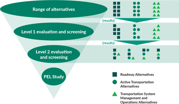
The study team developed a draft range of alternatives that address issues in the study area. Analysis of the alternatives may determine that mixing and matching options may best fit the area’s needs. Several alternatives look similar but have unique design features that would change traffic flow, safety, and access.
The draft range of alternatives includes several design options. We invite your input on the draft range of alternatives on the Share your input page.
Roadway range of alternatives
All alternatives under consideration include either additional general purpose or high occupancy vehicle (HOV) lanes and active transportation facilities.
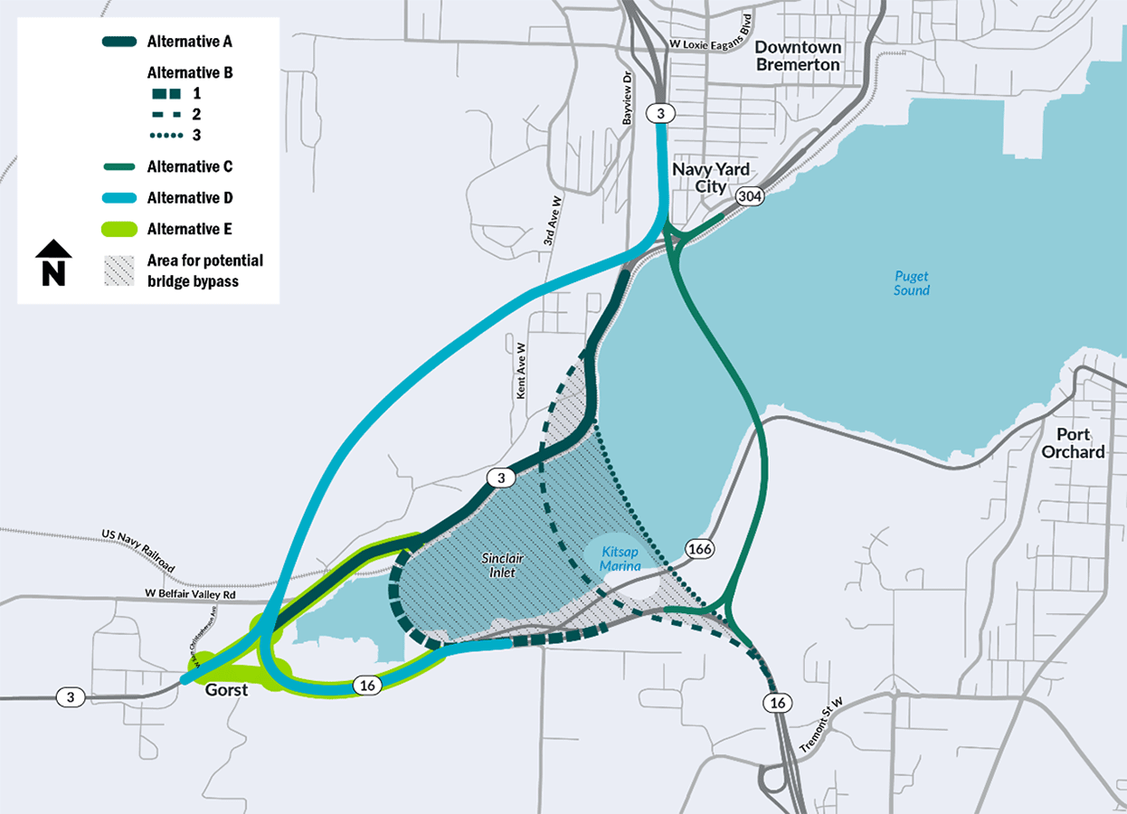
Alternative A: Widen SR 3
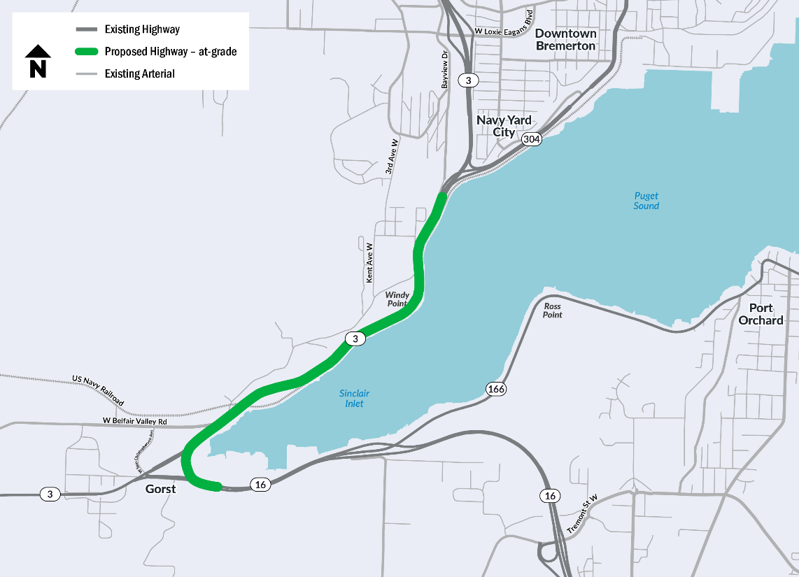
Alternative A widens SR 3 to three or more lanes in each direction between SR 304 and Gorst. This alternative would maintain traffic flow and may alleviate congestion through the Gorst area by increasing capacity. The added lanes would either be general purpose or high occupancy vehicle (HOV) lanes.
Alternatives A-1 and A-2 describe how improvements would be made along the Gorst commercial area.
Alternative A-1: Elevated roadway
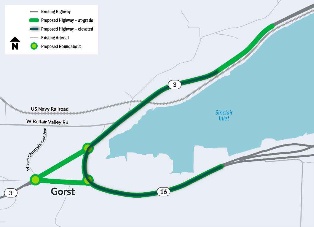
Alternative A-1 builds an elevated overpass that would move regional traffic above the Gorst commercial area to improve congestion and safety. This alternative elevates SR 16 east of Gorst until it passes over the U.S. Navy Railroad. Local traffic through Gorst would continue at-grade, below the elevated roadway. This would include two at-grade roundabouts to allow for access to local businesses and residences.
Alternative A-2: Elevated roundabout
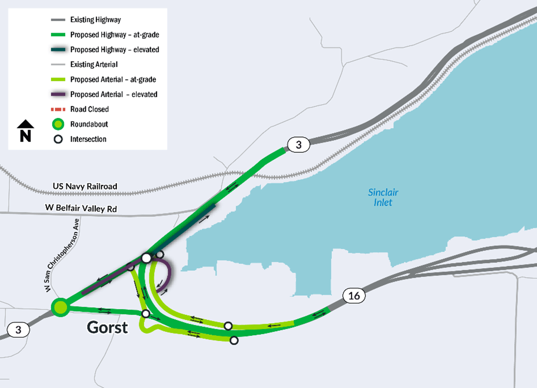
Alternative A-2 adds an elevated roundabout, two at-grade roundabouts, and two frontage roads through Gorst. Business access is provided by the frontage roads with an overpass between the east and west sides of SR 16. The elevated roundabout and frontage roads would allow regional traffic to continue along the roadway without being disrupted by traffic accessing local businesses and residences.
Alternative B: Bridge bypass of Gorst and Naval Railroad Bridge
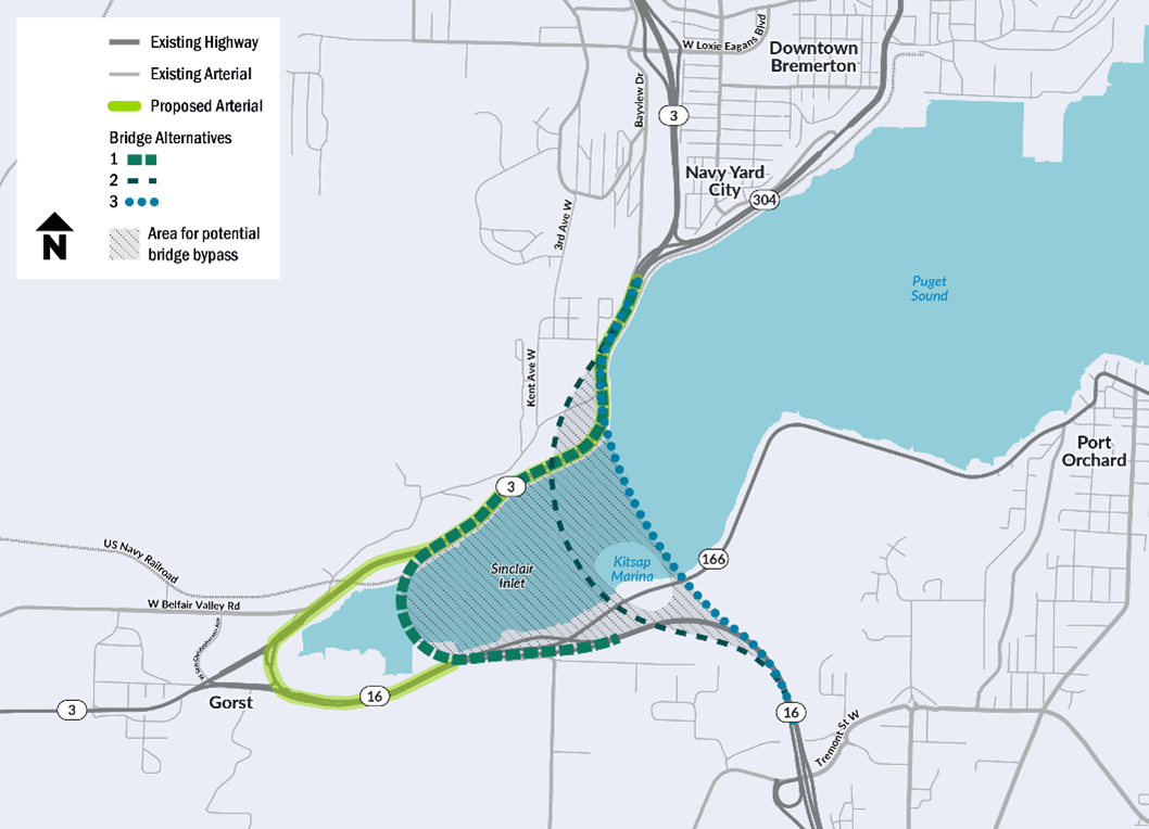
Alternative B builds a new bridge across Sinclair Inlet to connect SR 16 and SR 3. The existing section of SR 3 between Gorst and the north end of the new bridge would be used as an arterial roadway, for active transportation facilities, or both. Diverting traffic from the Gorst area would reduce delays and increase safety performance by reducing conflicts between regional and local traffic. This alternative would increase resiliency to climate change by raising the elevation of the roadway.
- This alternative includes a range of possible alignments that could be located anywhere within the hatched area shown in the map legend above. The crossing alignments all function similarly but would have differences related to speed limit, bridge lengths, and marine navigation on the inlet.
- The alignment closest to the shoreline would have the shortest bridge. The bridge would need a tight curve, so would require a lower speed limit.
- The middle and furthest alignments would have longer bridge structures across the inlet. These bridges would be less curved so would allow higher speed limits.
- The alignment furthest from the shoreline would need to accommodate boats accessing the Kitsap Marina.
- Alternative B would be paired with Alternative E to reconstruct the existing SR 3 highway through Gorst into a road focused on serving local traffic.
- The Alternative B alignments would bypass the Naval Railroad Bridge. Vehicles too tall to pass under the railroad bridge would use the Alternative B bridge.
- For Alternative B, active transportation facilities could be built on the bridge alignments and/or along the existing SR 3/SR 16 corridor.
Alternative C: Replace SR 3 with Bridge
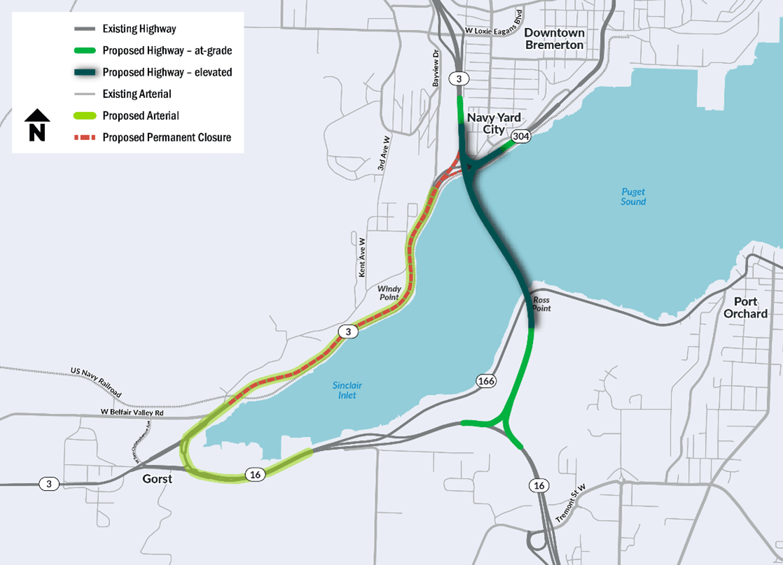
Alternative C builds a new bridge across Sinclair Inlet that connects SR 16 to SR 3 and SR 304. An interchange where the bridge meets SR 3 and SR 304 would allow travel from both highways and to and from SR 16. The existing section of SR 3 from the north side of Gorst to the SR 304 interchange would be used as a local arterial roadway or potentially closed to vehicle traffic. A portion of the existing SR 3 roadway along Sinclair Inlet could be converted to active transportation facilities. Diverting traffic from the Gorst area would reduce delays and increase safety performance by reducing conflicts between regional and local traffic.
- Alternative C would be paired with Alternative E to reconstruct the existing SR 3 highway through the Gorst commercial area into a road focused on serving local traffic.
- For Alternative C, active transportation facilities could be built on the bridge alignment or along the existing SR 3/SR 16 corridor.
- The Alternative C alignment would bypass the Naval Railroad Bridge. Vehicles too tall to pass under the railroad bridge would use the Alternative C bridge.
Alternative D: Land bypass
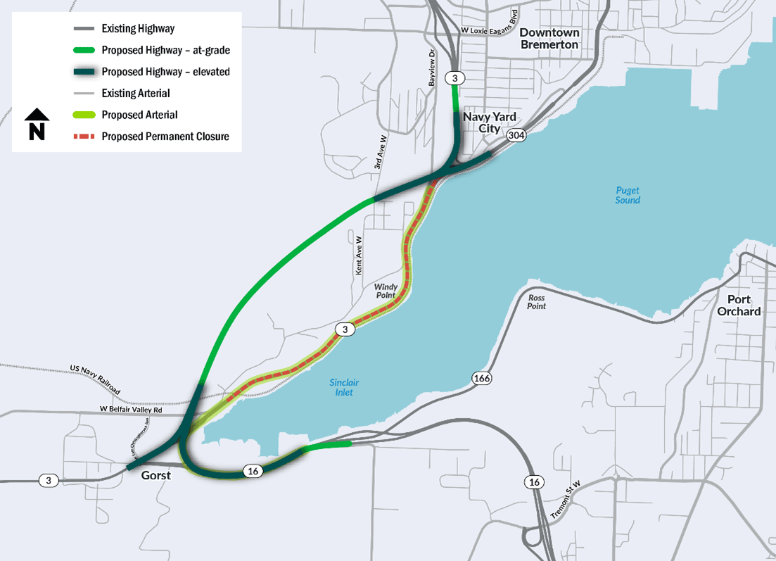
Alternative D elevates the roadway along the Gorst commercial area and builds a new inland roadway alignment for SR 3. This alternative elevates SR 16 along the Gorst commercial area, continues at-grade through the Sherman Heights area, then elevates again at a new interchange with SR 3. Local traffic through Gorst would continue underneath the elevated roadway and would maintain access to SR 16 and SR 3. Moving regional traffic to an inland alignment would support highway climate resiliency by moving SR 3 away from the shoreline.
- Alternative D would be paired with Alternative E to reconstruct the existing SR 3 highway through Gorst into a road focused on serving local traffic.
- For Alternative D, active transportation facilities could be built along the bypass alignment or along the existing SR 3/SR 16 corridor. A route along the existing corridor would provide flatter grades and more scenic views along Sinclair Inlet.
- The Alternative D alignment would bypass the Naval railroad bridge. Vehicles too tall to pass under the railroad bridge would use the Alternative D roadway.
Alternative E: Roundabout triangle
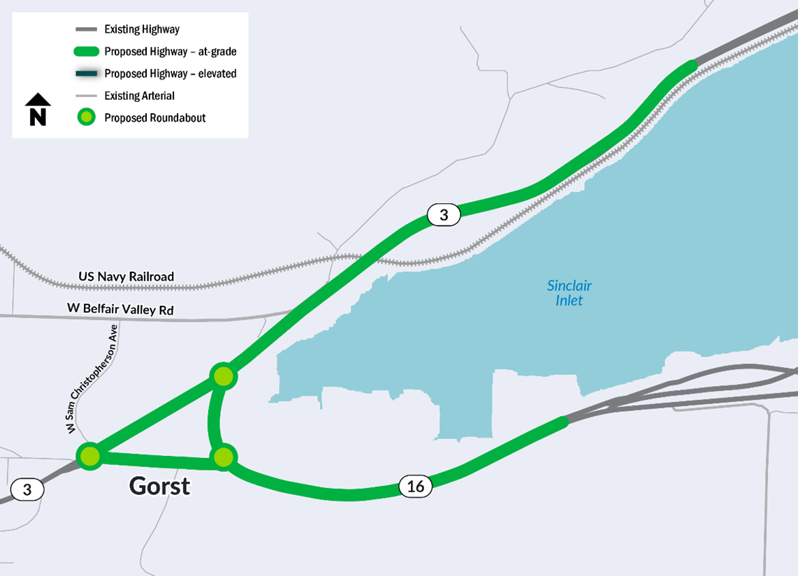
Alternative E builds a triangle of roundabouts through Gorst. This alternative connects to the fish passage and roundabout project at the intersection of SR 3 and W Sam Christopherson Avenue. It would update the roads in between the roundabouts to follow design standards for lower speed arterials and to incorporate active transportation facilities.
- Alternative E would be paired with either Alternative B, C, or D to divert regional traffic from Gorst. This would reduce congestion for regional traffic while still supporting Gorst’s economic growth by maintaining access to local businesses.
Active transportation alternatives
The study team is also analyzing potential active transportation facilities in the study area. Active transportation facilities include safe routes and connections for people walking, biking, or rolling.
These active transportation facilities will be compatible with all the roadway alternatives. WSDOT is considering how alternatives would connect to existing local active transportation facilities, common destinations, existing infrastructure and residential areas. When studying these alternatives, the team will consider path directness, safety, accessibility for all users, and potential impacts from sea level rise and climate change.
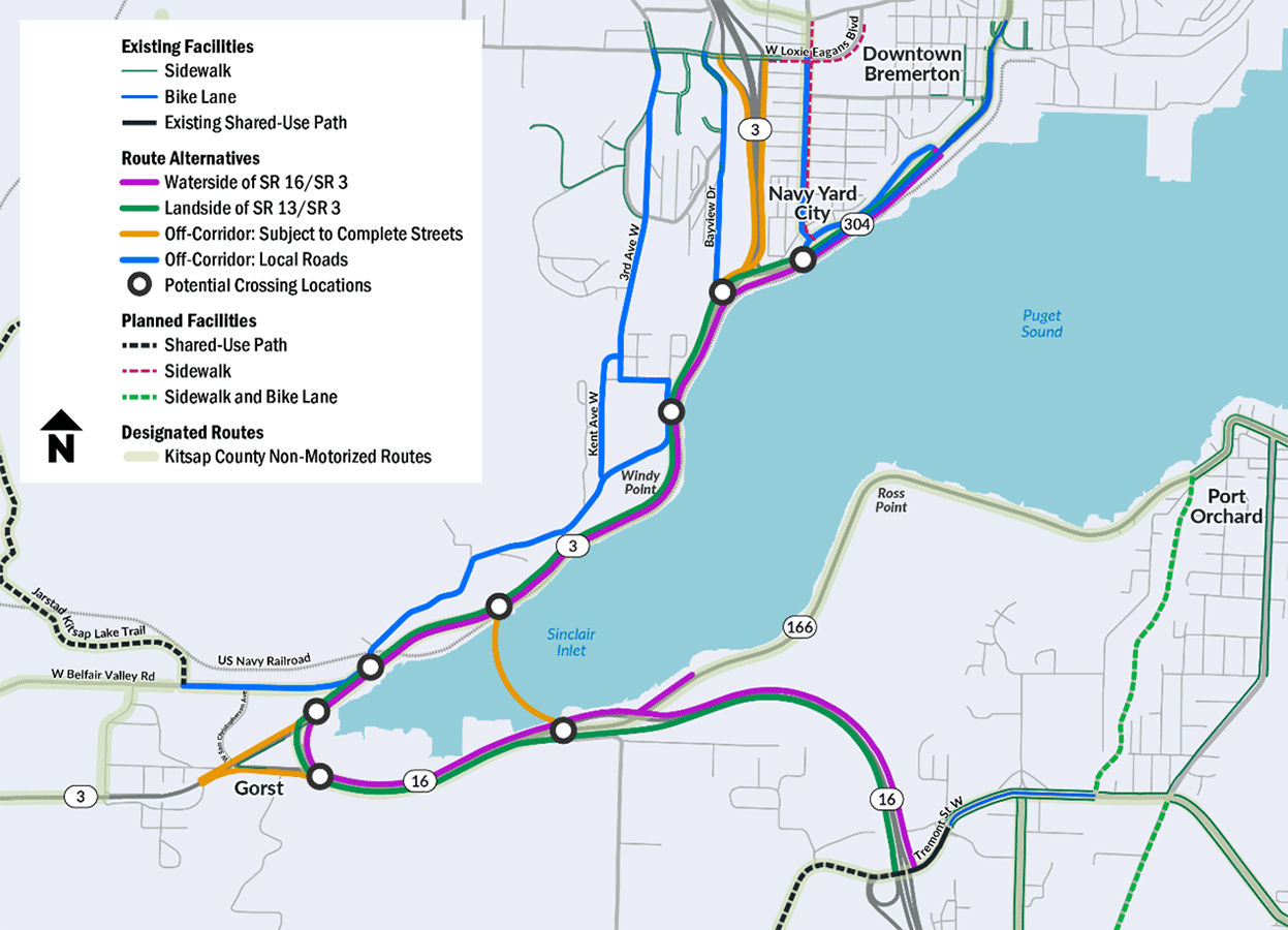
Waterside route (above in purple)
This alignment offers the most direct route for people walking, biking, or rolling. It has minimal grade changes, scenic views, and easy access to the shoreline of Sinclair Inlet. This alignment connects to existing bike lanes along SR 304 in Bremerton and the shared-use path along Tremont Street W in Port Orchard.
For this route, WSDOT will consider proximity to the railroad and potential driveway crossings. We will also consider effects on sensitive nearshore habitat and potential impacts from sea level rise. The route would need crossings in Bremerton, Gorst, and Port Orchard to access the facility.
Landside route (above in green)
Similar to the Waterside route, the Landside alignment provides a direct route for users. This option has minimal grade change and wouldn’t require crossings to access the facility. This alignment connects to existing bike lanes along SR 304 in Bremerton and the proposed shared-use path along Old Clifton Road in Port Orchard.
For this route, WSDOT will consider the need for grading to make the path more accessible. We will also consider potential driveway crossings and uncontrolled traffic lanes at several interchanges along the route.
Off-corridor State Routes (above in orange)
This alignment uses State Routes to connect to the study corridor. As state routes, these segments are subject to Complete Streets design requirements. This means that any combination of the Off-Corridor segments with the Waterside or Landside routes would require coordination with partners to build a continuous facility.
Off-corridor local roads (above in blue)
Instead of State Routes, these alignments use local roads along the study corridor. Local roads include National Avenue, Sherman Heights Boulevard, and W Charleston Beach Road. Local roads can be safer because of lower traffic volumes and speeds. Local roads can also be steeper and provide a less direct connection for people walking, biking, or rolling.
Since these are local roads outside of WSDOT’s jurisdiction, this alternative would require coordination with Kitsap County and the City of Bremerton.
Transportation System Management and Operations alternatives
In addition to the above alternatives, the PEL study will evaluate Transportation System Management and Operations (TSMO) non-roadway options. TSMO strategies help make existing transportation systems safer and more efficient. Using TSMO strategies focuses on affordable and quick solutions that work for different types of transportation, across different areas, and on all kinds of roads. The study team is considering the following TSMO strategies.
- Vehicle ferry (Port Orchard to Bremerton)
- Shipyard shift revisions (i.e. modifying the times when shifts begin and/or end to minimize overlap with typically busy travel periods)
- Additional worker buses
- Additional transit service
- Additional parking, including park and ride lots or designated carpool or vanpool parking
- Assistance creating carpools or vanpools
- Commute trip reduction policies, such as work hour flexibility or telecommuting
- Charge parking fees
- Public transit incentives such as bus pass subsidies
- Rideshare programs, ‘Dial and Ride’ service, and Paratransit service
- Employee challenges and rewards for carpooling or using transit and active transportation