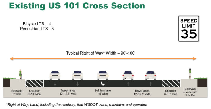
Roadway configuration
US 101 is currently a five-lane roadway with two lanes northbound, two lanes southbound, and a center left turn lane. The travel lanes are between 12 and 13 feet wide, while the center turn lane is 15 feet wide. Shoulders on either side of US 101 vary between 8 and 10 feet wide. US 101 narrows to one through lane in either direction south of Heath Street. The posted speed on US 101 is 35 miles per hour.
Sidewalks have been constructed on both sides of US 101, with a non-separated five-foot-wide sidewalk on the west side and a four-foot-wide sidewalk on the east separated from the roadway by a two-foot gravel strip.
Dedicated bicycle facilities have been provided on US 101 within the study limits. Bicyclists navigating the corridor may ride in the sidewalk, the travel lanes, or on the wide shoulder.
Traffic operations
A traffic study was done along the project area to see how US 101 is currently handling vehicles and how the corridor function in the future. Traffic counts at key intersections were checked for delays, a speed study looked at whether drivers follow speed limits and the road’s overall traffic capacity was also reviewed.
Intersection operations
The current and future traffic at key intersections on US 101 were compared against Level of Service (LOS) standards to find any possible traffic delays or congestion.
- LOS measures how much delay drivers face at an intersection and gives it a rating from A to F.
- LOS A means traffic moves smoothly with little delay.
- LOS F means heavy traffic with long delays.
For US 101, the goal is to keep traffic at LOS C or better.
The traffic study reviewed the study intersections during the AM peak hours (between 7 a.m. – 9 a.m.) and the PM peak hours (between 4 p.m. – 6 p.m.). During both the AM and PM peak hours, all intersections within the study are operating at LOS C or better currently and into the future.
Findings from existing conditions review
Traffic volumes:
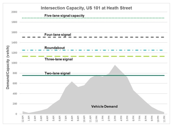
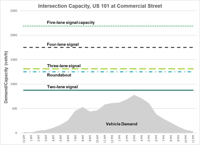
US 101 has excess capacity for the amount of traffic seen today and what we expect to see in the future. Even if one lane was taken out in either direction, all the intersections we studies would still run smoothly and meet WSDOT standards.
Speed study
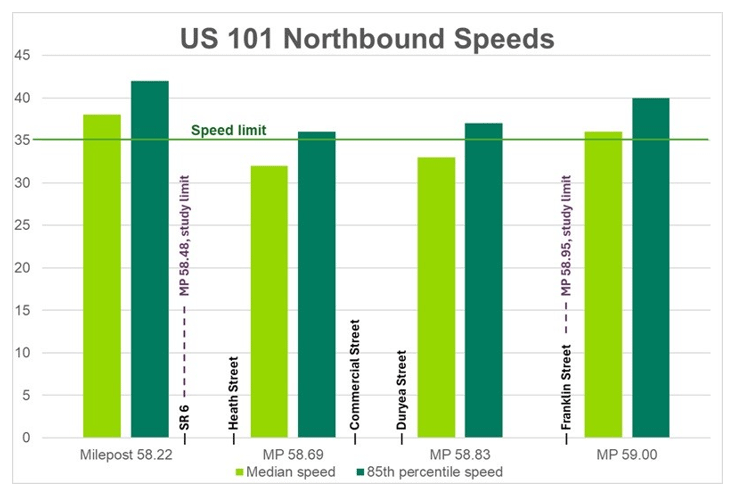
The speed study took speed measurements of traffic in both directions at four locations – before Franklin Street, between Franklin Street and Duryea Street, between Commercial Street and Heath Street, and south of the US 101/SR 6 roundabout. In the past, posted speeds on state highways were determined using the 85th percentile speed, or the speed that 85 percent of drivers were travelling on a given roadway. For this study, we found that drivers northbound and southbound on US 101 generally follow the posted speeds.
Findings from existing conditions review
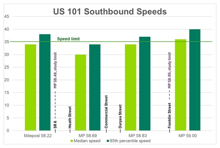
Speed study:
Northbound and Southbound drivers are generally following the posted speed of 35 MPH. The graphs on this board show both the median (middle) speed and the speed that 85 percent of drivers were travelling (also known as the 85th percentile speed).
Roadway capacity
An analysis of roadway capacity was completed to determine whether US 101 has excess capacity. It found that the two traffic lights at Heath Street and Commercial Street can handle more cars than they currently do, or are expected to in the future. These intersections see up to 900 vehicles per hour during the busiest times, but they can handle between 1,750 and 1,900 vehicles per hour. When a road has more space than needed, it may be a good fit for a roadway reallocation, also known as a road diet. This means redesigning the road, like removing or narrowing lanes, to make room for people walking or biking.
Removing one lane in each direction on US 101 would still allow traffic to flow well and meet standards, while creating space for safer bike and pedestrian improvements.
Bicycle and pedestrian level of traffic stress
Bicycle level of traffic stress
Right now, US 101 doesn’t have space for people riding bikes. With more than 9,000 vehicles using the road each day, a speed limit of 35 MPH, and two lanes in each direction, the bicycle Level of Traffic Stress in the study area is rated a 4—which means it feels unsafe or uncomfortable for most bicyclists.
Pedestrian level of traffic stress
US 101 does have sidewalks on both sides, but crossing the road is hard because it’s wide. Also, the sidewalks are narrow. State routes should have sidewalks at least five feet wide. While the west sidewalk meets this standard, the east one is only four feet wide. Because of the road’s setup, speed limit, and the narrow sidewalk, the pedestrian Level of Traffic Stress is rated a 3, meaning it may feel challenging for many people walking.