SR 112 North Olympic Peninsula - Highway Resilience Project

Share SR 112 North Olympic Peninsula - Highway Resilience Project on Facebook Share SR 112 North Olympic Peninsula - Highway Resilience Project on X (formerly Twitter) Share SR 112 North Olympic Peninsula - Highway Resilience Project on Linkedin Email SR 112 North Olympic Peninsula - Highway Resilience Project link

Welcome

The Washington State Department of Transportation has received $24.8 million from the National Oceanic and Atmospheric Administration. The grant money goes towards climate change-related issues affecting State Route 112. With the grant, WSDOT will work with the Makah Tribe to conduct several studies of SR 112. Funding will also go towards a project to stabilize several known unstable slopes, increase the resiliency of the shoreline in select areas, and raise the highway in key areas along the corridor.

SR 112 is an important east-west connection on the north Olympic Peninsula. It connects the Makah Reservation, Sekiu, Pysht, Clallam Bay and the remote communities of the Lower Elwha Klallam Tribe to the rest of the peninsula.

Parts of SR 112 often see flooding, landslides, shoreline erosion and washouts. These events can result in highway closures. WSDOT will work with local tribes and governments to assess the network of area logging roads. The goal is to find possible access alternatives and develop safer detour routes.

WSDOT will also work to develop nature-based approaches to combat other issues on SR 112. These studies will come up with recommendations for future projects. These projects will address sea level rise and coastal flooding threats.

Funding for this project was provided in part by the Washington State Department of Ecology through funding from the Inflation Reduction Act administered by the Office for Coastal Management, National Oceanic and Atmospheric Administration.

The money given to WSDOT is part of a larger $73.6 million federal grant award to the Department of Ecology to tackle climate-related threats.

The projects
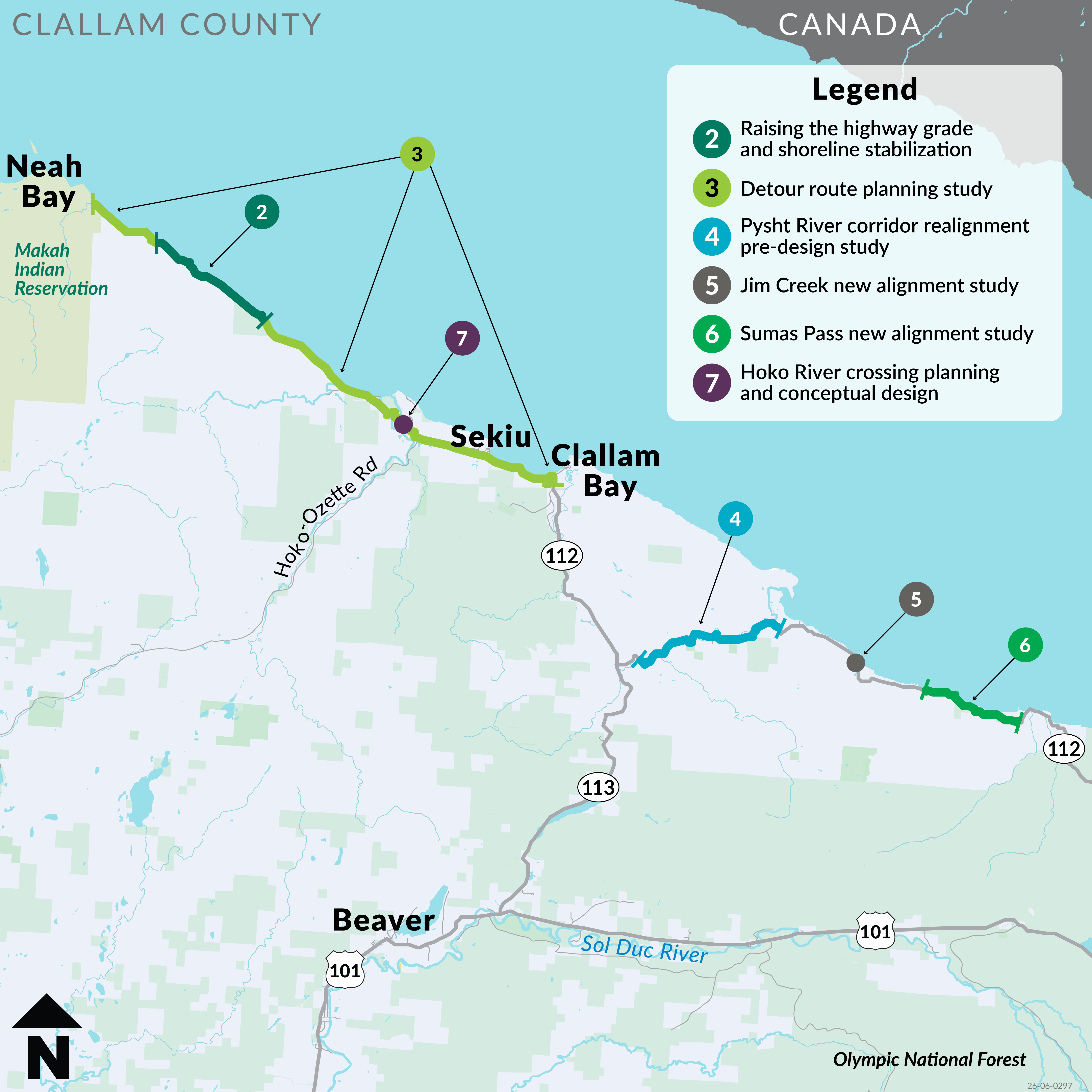
2 – SR 112 raising the highway grade and shoreline stabilization

Overview: This project will design and construct unstable slope and shoreline stabilization measures on SR 112 from mileposts 4.7 to 4.9 and 5.45 to 5.5. It will raise the highway grade from milepost 6 to 6.33. Two culverts will be replaced at mileposts 6.01 and 6.55. It will also mitigate select rock and soil slope failures on the upslope side of the highway between mileposts 1.99 and 6.4.

Timeline:

  • 2025
    Funding secured
  • 2026
    Planning & Design
  • 2027
    Design & Outreach
  • 2028
    Construction
  • 2029
    Construction Complete

3 - SR 112 detour route planning study

Overview: A planning study to analyze existing logging road network near SR 112 between Neah Bay (MP 0) and Clallam Bay (MP 17). The study will look at these roads to see if any can be improved for an emergency access detour. It will also look at possible right-of-way or land use access agreements. This would improve access for the Makah Tribe.

Timeline:

  • 2025
    Study Begins. Analysis begins, including identifying the existing detour route and identifying landowners along the existing detour route. Meeting with local partners to hear what they envision for a detour route.
  • 2026
    Analysis continues. Field work begins to determine improvements needed along the existing detour route.
  • 2027
    Field work and analysis conclude. Report drafting begins.
  • 2028
    Final Report with detour route recommendations published.

4 – SR 112 Pysht River Valley corridor realignment study

Study overview: State Route 112 near the Pysht River experiences frequent flooding and erosion of the roadway. This often results in roadway closures. This planning study will develop and analyze options to address flooding and erosion on SR 112.

Timeline:

WSDOT anticipates starting work on the planning study in late 2026. The study will be finished by 2029.

5 – SR 112 Jim Creek new alignment study

Study overview: A planning study to look at potential new highway alignments over creek valley. The study will compare the costs of a new alignment against improvements to the existing alignment. The study will also collect subsurface and landslide data. The aim is to improve resilience of SR 112 in the Jim Creek area (MP 32 vicinity).

Timeline:

  • 2025
    Study analysis begins.
  • 2026
    Analysis continues and field work begins.
  • 2027
    Field and analysis work concludes. Report drafting begins.
  • 2028
    Final report with detour route recommendations published.

6 – SR 112 Sumas Pass new alignment study

Study overview: A planning study to look for ways to improve resilience on SR 112 through Sumas Pass (MP 37 vicinity). The area often experiences landslides and road closures. The study will look at potential new highway alignments and improvements to the existing alignment.

Timeline:

  • 2025
    Study analysis begins.
  • 2026
    Analysis continues and field work begins.
  • 2027
    Field work and analysis conclude. Report drafting begins.
  • 2028
    Final report with detour route recommendations published.

7 – SR 112 Hoko River crossing replacement study

Study overview: This study will look for and recommend a solution to mitigate flooding on SR 112 near the Hoko River crossing. The crossing is near milepost 11.8 and often has to close due to flooding. The study will look at several alternatives to achieve this goal. These alternatives include raising the elevation SR 112 or replacing the existing bridge with a longer bridge. It will also look at adding relief crossings. The final recommendation may be a combination of these alternatives. The study will also look at relocating the highway to an area less vulnerable to flooding. The study will include analysis of climate resilience and will consider sea level rise and increased river flows.

Timeline:

  • 2025
    Study begins.
  • 2027
    Prepare report. Public and Tribal engagement to share alternatives analysis and recommended alternative.
  • 2028
    Final report published.

Welcome

The Washington State Department of Transportation has received $24.8 million from the National Oceanic and Atmospheric Administration. The grant money goes towards climate change-related issues affecting State Route 112. With the grant, WSDOT will work with the Makah Tribe to conduct several studies of SR 112. Funding will also go towards a project to stabilize several known unstable slopes, increase the resiliency of the shoreline in select areas, and raise the highway in key areas along the corridor.

SR 112 is an important east-west connection on the north Olympic Peninsula. It connects the Makah Reservation, Sekiu, Pysht, Clallam Bay and the remote communities of the Lower Elwha Klallam Tribe to the rest of the peninsula.

Parts of SR 112 often see flooding, landslides, shoreline erosion and washouts. These events can result in highway closures. WSDOT will work with local tribes and governments to assess the network of area logging roads. The goal is to find possible access alternatives and develop safer detour routes.

WSDOT will also work to develop nature-based approaches to combat other issues on SR 112. These studies will come up with recommendations for future projects. These projects will address sea level rise and coastal flooding threats.

Funding for this project was provided in part by the Washington State Department of Ecology through funding from the Inflation Reduction Act administered by the Office for Coastal Management, National Oceanic and Atmospheric Administration.

The money given to WSDOT is part of a larger $73.6 million federal grant award to the Department of Ecology to tackle climate-related threats.

The projects

2 – SR 112 raising the highway grade and shoreline stabilization

Overview: This project will design and construct unstable slope and shoreline stabilization measures on SR 112 from mileposts 4.7 to 4.9 and 5.45 to 5.5. It will raise the highway grade from milepost 6 to 6.33. Two culverts will be replaced at mileposts 6.01 and 6.55. It will also mitigate select rock and soil slope failures on the upslope side of the highway between mileposts 1.99 and 6.4.

Timeline:

  • 2025
    Funding secured
  • 2026
    Planning & Design
  • 2027
    Design & Outreach
  • 2028
    Construction
  • 2029
    Construction Complete

3 - SR 112 detour route planning study

Overview: A planning study to analyze existing logging road network near SR 112 between Neah Bay (MP 0) and Clallam Bay (MP 17). The study will look at these roads to see if any can be improved for an emergency access detour. It will also look at possible right-of-way or land use access agreements. This would improve access for the Makah Tribe.

Timeline:

  • 2025
    Study Begins. Analysis begins, including identifying the existing detour route and identifying landowners along the existing detour route. Meeting with local partners to hear what they envision for a detour route.
  • 2026
    Analysis continues. Field work begins to determine improvements needed along the existing detour route.
  • 2027
    Field work and analysis conclude. Report drafting begins.
  • 2028
    Final Report with detour route recommendations published.

4 – SR 112 Pysht River Valley corridor realignment study

Study overview: State Route 112 near the Pysht River experiences frequent flooding and erosion of the roadway. This often results in roadway closures. This planning study will develop and analyze options to address flooding and erosion on SR 112.

Timeline:

WSDOT anticipates starting work on the planning study in late 2026. The study will be finished by 2029.

5 – SR 112 Jim Creek new alignment study

Study overview: A planning study to look at potential new highway alignments over creek valley. The study will compare the costs of a new alignment against improvements to the existing alignment. The study will also collect subsurface and landslide data. The aim is to improve resilience of SR 112 in the Jim Creek area (MP 32 vicinity).

Timeline:

  • 2025
    Study analysis begins.
  • 2026
    Analysis continues and field work begins.
  • 2027
    Field and analysis work concludes. Report drafting begins.
  • 2028
    Final report with detour route recommendations published.

6 – SR 112 Sumas Pass new alignment study

Study overview: A planning study to look for ways to improve resilience on SR 112 through Sumas Pass (MP 37 vicinity). The area often experiences landslides and road closures. The study will look at potential new highway alignments and improvements to the existing alignment.

Timeline:

  • 2025
    Study analysis begins.
  • 2026
    Analysis continues and field work begins.
  • 2027
    Field work and analysis conclude. Report drafting begins.
  • 2028
    Final report with detour route recommendations published.

7 – SR 112 Hoko River crossing replacement study

Study overview: This study will look for and recommend a solution to mitigate flooding on SR 112 near the Hoko River crossing. The crossing is near milepost 11.8 and often has to close due to flooding. The study will look at several alternatives to achieve this goal. These alternatives include raising the elevation SR 112 or replacing the existing bridge with a longer bridge. It will also look at adding relief crossings. The final recommendation may be a combination of these alternatives. The study will also look at relocating the highway to an area less vulnerable to flooding. The study will include analysis of climate resilience and will consider sea level rise and increased river flows.

Timeline:

  • 2025
    Study begins.
  • 2027
    Prepare report. Public and Tribal engagement to share alternatives analysis and recommended alternative.
  • 2028
    Final report published.
Page last updated: 07 Oct 2026, 08:13 AM