Project areas
There are five areas where work is planned.

- SR 109: Unnamed Stream to Pacific Ocean at milepost 37.4 Coho, resident trout, steelhead, sea run cutthroat. 0.6 mile of potential habitat gain
- SR 109: Unnamed Stream to Pacific Ocean at milepost 36.4 Coho, resident trout, steelhead, sea run cutthroat. 1.9 miles of potential habitat gain
- SR 109: Unnamed Stream to Pacific Ocean at milepost 36.3 Coho, resident trout, steelhead, sea run cutthroat. 0.5 mile of potential habitat gain
- SR 109: Unnamed Stream to Pacific Ocean at milepost 33.8. Bull trout, coho, resident trout, steelhead, sea run cutthroat. 1.2 miles of potential habitat gain
- SR 109: Wain Creek to Pacific Ocean at milepost 33.1 Coho, resident trout, steelhead, sea run cutthroat. 2.5 miles of potential habitat gain
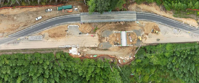
How the work is done
The work requires heavy construction. Workers dig out the entire roadway. Crews replace the existing culvert with a new fish passable structure, typically a culvert or a bridge. The new structure is much larger. WSDOT will use temporary lanes and traffic signals at each location. Travelers will see a reduced speed limit approaching each work zone.
Work during the busy summer travel season
Some of the work crews will perform takes place in the water. There is a limited time frame they are allowed to do this that is determined by the Department of Fish and Wildlife in consultation with Quinault Indian Nation Natural Resources staff. We call it a “fish window.” This is when working in the water will be the least disruptive to aquatic life. The fish window is not the same at every fish passage job but is usually in mid to late summer.
WSDOT knows this is at the very least inconvenient. Crews will work as quickly as possible to get the job done.