I-5 – Tributaries to Friday, Lake & Chuckanut Creeks – Fish Passage
On this page: Welcome! | What to expect in 2025: key milestones | What to expect in 2026 and 2027 | The Bellingham Rock | Project funding and benefits | Stay connected
Welcome!
Beginning in late April 2025, the Washington State Department of Transportation will start construction to remove 17 barriers to fish passage and replacing those barriers with 10 new, structures that fish can swim through in south Whatcom and north Skagit counties. This work improves stream connectivity for Unnamed tributaries to Friday Creek, Lake Creek, Unnamed tributary to Lake Creek, and Chuckanut Creek along a 6-mile stretch of Interstate 5, south of Bellingham and north of Burlington.

Project overview
This project represents another milestone in WSDOT’s continued efforts to remove fish barriers and restore fish passage to streams throughout Washington State. The goal of the project is to replace existing fish barrier crossings with structures that allow fish to pass through.

This project will affect the I-5 corridor near the following mileposts between Bellingham and Burlington:
- Chuckanut Creek: milepost 247
- Unnamed tributaries to Friday Creek: milepost 241
- Lake Creek: milepost 245
- Unnamed tributary to Lake Creek: milepost 246
What to expect in 2025: key milestones
Construction is scheduled 2025 to 2027
The project’s first season in 2025 will span from May through October. During this time, crews will construct the Lake Creek and Unnamed tributaries to Friday Creek culverts. The second and third season of work will be in 2026 and 2027, respectively and will consist of constructing the Chuckanut Creek and Unnamed tributary to Lake Creek sites, in addition to completing stream restoration and landscaping work at the Unnamed tributaries to Friday Creek site.
2025 Project timeline
Lake Creek – Milepost 246
- May 2025
Bypass road construction begins at Lake Creek with nightly single-lane I-5 closures and intermittent Lake Samish Road closures. - June 2025
SB I-5 shifts onto two-lane median bypass. After SB culvert construction finishes, SB I-5 traffic returns to original alignment. - July 2025
NB I-5 median bypass road construction finishes and traffic shifts onto bypass to allow construction of the NB culvert. - Aug. 2025
NB I-5 traffic returns to original alignment with intermittent nightly single-lane closures for landscaping.
Unnamed Tributary to Friday Creek – Milepost 241
- Aug. 2025
I-5 crossover construction begins at Friday Creek with nightly single-lane closures. NB and SB I-5 reduce to a single lane for two weeks to construct the NB culvert. Lake Samish Road on-ramp to NB I-5 also closes. - Sept. 2025
I-5 crossover configured for SB construction with nightly single-lane closures. NB and SB I-5 reduce to a single lane for two weeks to build the SB culvert. SB I-5 off-ramp to Lake Samish Road also closes. - Oct. 2025
NB and SB I-5 return to original alignment. Lake Samish Road closes for one month for culvert construction.
Lake Creek
Construction will begin in May 2025 at the Lake Creek site (milepost 245). A median bypass road will be constructed between northbound and southbound I-5 lanes to move traffic away from the work area.
Once traffic has been moved onto the median bypass road then excavation and removal of the old fish barrier will occur, followed by installation of the new culvert. Once the new culvert has been backfilled and the roadway restored, traffic will move back onto the existing roadway. When one side of I-5 has been constructed, the median bypass will be reconfigured to support work on the other side of I-5.
Most of the work at the Lake Creek site will be completed by August 2025.
Friday Creek
Beginning in August 2025, and after the Lake Creek culverts have been installed, work will commence at the Unnamed Tributaries to Friday Creek site (milepost 241). The order of work will occur very similarly to what was done at Lake Creek. People who travel on Lake Samish Road will experience a guided detour route in 2026 while the road is closed just west of I-5. Additionally, in 2026, crews will continue in stream and restoration work.
During the first season of construction, crews should be off the roadway by November 2025.

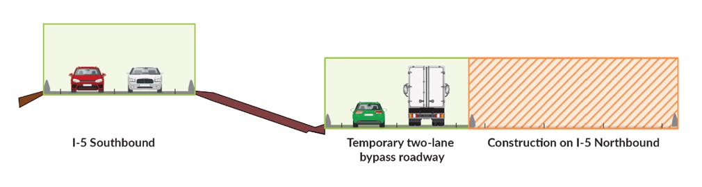
Traffic bypass on the I-5 median
Travelers on I-5 will use the two-lane temporary bypasses through the summer while the Lake Creek culverts are under construction.
How long will traffic be on the bypass?
Bypass roads on I-5 will be constructed to divert traffic around the work area. For 2025, this will occur at the Lake Creek and Unnamed tributaries to Friday Creek sites (mileposts 245 and 241). Construction of these temporary roads will begin in May, and completion will occur in October this year. In 2026, similar bypass roads will be constructed at the Unnamed tributary to Lake Creek (milepost 246) and Chuckanut Creek sites (milepost 247).

- Speed limits will be reduced once traffic is shifted to the bypass roads.
- Two lanes of traffic will be maintained in each direction at the Lake Creek, Unnamed tributary to Lake Creek, and Chuckanut Creek site.
- During I-5 culvert construction at the Unnamed tributaries to Friday Creek site, both directions of I-5 will be reduced to a single lane and placed into a crossover using the opposing direction of I-5. Delays are expected during peak hours during this time.

What to expect in 2026 and 2027
2026 project timeline
Chuckanut Creek – Milepost 246
- Apr. 2026
I-5 bypass road at Chuckanut Creek built with nightly single-lane closures. Old Samish Road closes. - May 2026
SB I-5 shifts to Old Samish Road. NB I-5 shifts onto bypass road. Work begins on SB bridge and half of NB bridge. - June 2026
Work on SB and half of NB bridge continues. - July 2026
SB I-5 traffic shifts onto original configuration on new bridge. NB I-5 shifts onto the portion of the new bridge. - Aug. 2026
Work begins on other half of NB bridge and Old Samish Road bridge. - Sept. 2026
Work on NB and Old Samish bridges finishes. - Oct. 2026
NB I-5 and Old Samish Road return to original configuration on new bridge.
Unnamed Tributary to Lake Creek – Milepost 246
- May 2026
Unnamed tributary to Lake Creek bypass road construction begins with nightly single-lane closures. - June 2026
NB I-5 shifts onto SB I-5, while SB I-5 shits to SB I-5 off-ramp to North Lake Samish for work on NB culvert. - July 2026
NB I-5 shifts to original alignment. SB I-5 remains on off-ramp to North Lake Samish for construction of SB culvert. - Aug. 2026
SB I-5 shifts to original alignment. SB I-5 on- and off-ramps to North Lake Samish remain closed while new ramps are built. - Sept. 2026
Construction of new North Lake Samish on- and off-ramps finishes and all lanes of NB & SB I-5 open to traffic.
Unnamed tributary to Lake Creek: Two new, larger culverts
Unnamed tributary to Lake Creek will have a single culvert that crosses under both directions of I-5 (milepost 246). The culvert will be built in two phases, using traffic configurations similar to what is done in 2025. The southbound I-5 on- and off-ramps to N Lake Samish Drive (Exit 246) will also be reconfigured and relocated as part of this work.
Chuckanut Creek: Three Bridges
Chuckanut Creek bridges will be built using a phased construction approach and bypass roads to divert traffic around the work areas. All three bridges will be built and opened to travelers in 2026. Stream restoration work will follow in 2027.
Old Samish Road closure – April 2026
A portion of Old Samish Road will close for up to seven months in order to construct the Chuckanut Creek bridge. Travelers will be provided a signed detour around the closure.

The Bellingham Rock

What’s happening?
If you’ve driven northbound on I-5 near Bellingham, chances are you’ve noticed the Bellingham Rock painted with messages for decades. As part of our fish passage project at Friday, Lake, and Chuckanut Creeks, the Rock will need to be removed from its current spot. We understand this Rock isn’t just a boulder, it’s a beloved community billboard.
Why can’t the rock stay?
Due to safety concerns, the Rock cannot return to its original location once it’s removed. WSDOT and the Federal Highway Administration (FHWA) don’t permit its return to I-5 limited access areas, especially where it could encourage unsafe parking or pedestrian access along a busy interstate.
Yes, it’s historic
Because the Rock has served as a community message board for so long, it’s officially eligible for the National Register of Historic Places. We’ve signed a Memorandum of Agreement with FHWA and the Department of Archaeology and Historic Preservation, laying out the process we must follow.
We’ve also been consulting with Native American Tribes and engaging with other interested parties, including the City of Bellingham and the Bellingham Rock Facebook Group, as we evaluate next steps.
What’s the plan?
We’re putting together something called a Treatment Plan, a formal document that:
- Details how we’ve documented the Rock,
- Outlines requirements for the contractor during removal, and
- Explores possibilities for where the Rock might go next.
Finding the right home
The heart of the challenge is finding a new home that keeps the Rock’s spirit alive, public, visible, and safely accessible.
We’ve been asked about relocating it to nearby on- and off-ramps, but they still fall under highway access rules and pose real safety concerns. We’ve also reached out to local governments, universities, and adjacent property owners. While we have heard some private interest in accepting the Rock, private owners aren’t able to provide public access or visibility, which means the Rock wouldn’t continue its role as a community message board. And because we’re using public funds, we can’t pay to move it to a private space if the public can’t interact with it.
On top of that, we also need to consider the environmental impact of any potential relocation. WSDOT works hard to avoid or minimize harm to environmentally critical areas like streams, wetlands, and other sensitive habitats. These areas are protected under local, state, and federal laws and we take those responsibilities seriously.
We also have to think about what it means to maintain the Rock at a new site. If it’s moved to a location that allows continued public access, there could be long-term maintenance needs that WSDOT, or another host, would need to take on. That’s something we must factor in as we look for the best path forward.
What’s Next?
Here’s what we do know:
- The Rock will be removed as part of this project.
- It won’t be going back to its current location or any other spot within I-5 limited access.
- We’re documenting its history thoroughly and respectfully.
- And most importantly, while the Rock will be moved from its current location, no decision has been made yet about its final resting place.
We’re working with our partners to find a solution that honors what the Bellingham Rock has meant to the community and we’re hopeful we’ll find a place that reflects that in one way, shape or form.
Project funding and benefits
Project funding
This project is funded by Federal American Rescue Plan Act and State Move Ahead Washington funds. The total cost of the project is $159.6 million.
Project benefits
Restores habitat for fish
This project is removing 17 fish barriers and replacing them with 10 fish passable structures. Replacing the outdated culverts with new ones will open potential upstream habitat for salmon to spawn and grow. The new culverts and natural features will make it easier for fish to move through the creeks by slowing the water and creating a more natural stream environment.
A 2016 federal court injunction requires the state to significantly increase its efforts to remove state-owned culverts that block salmon, bull trout and steelhead habitats. The Injunction requires us to first evaluate if the crossing can be removed. By relocating the streams, seven additional stream crossings were eliminated. Rechanneling some of the tributaries, will create deeper, colder streams that help fish move through the area.
This reduces costs of installing additional structures and the long-term maintenance associated with each while ensuring fish can use more natural stream sections instead of streams under a highway structure.
Updating aging infrastructure and improving roadway resiliency
The new, larger culverts and bridges installed during this project will replace outdated culverts, which are usually a small pipe that run beneath the roadway, some of which are beginning to show signs of failure. These new structures are designed to current seismic standards, and the roadway is upgraded to current safety standards.
Removing invasive species and installing native landscape
The new streamswill include natural elements, such as logs and boulders to stabilize the channel, create habitat for fish and restore the natural flow of the streams that were disrupted when the original culverts were installed under the highway.
Stay connected
Madison Sehlke
WSDOT Communicator
madison.sehlke@wsdot.wa.gov
Megan Mosebar
WSDOT Project Engineer
megan.mosebar@wsdot.wa.gov